American Discovery Trail
Descripción
- Name American Discovery Trail (ADT)
- Distancia de sendero 8,000 km, 4,971 millas
- Duración en días 400 días
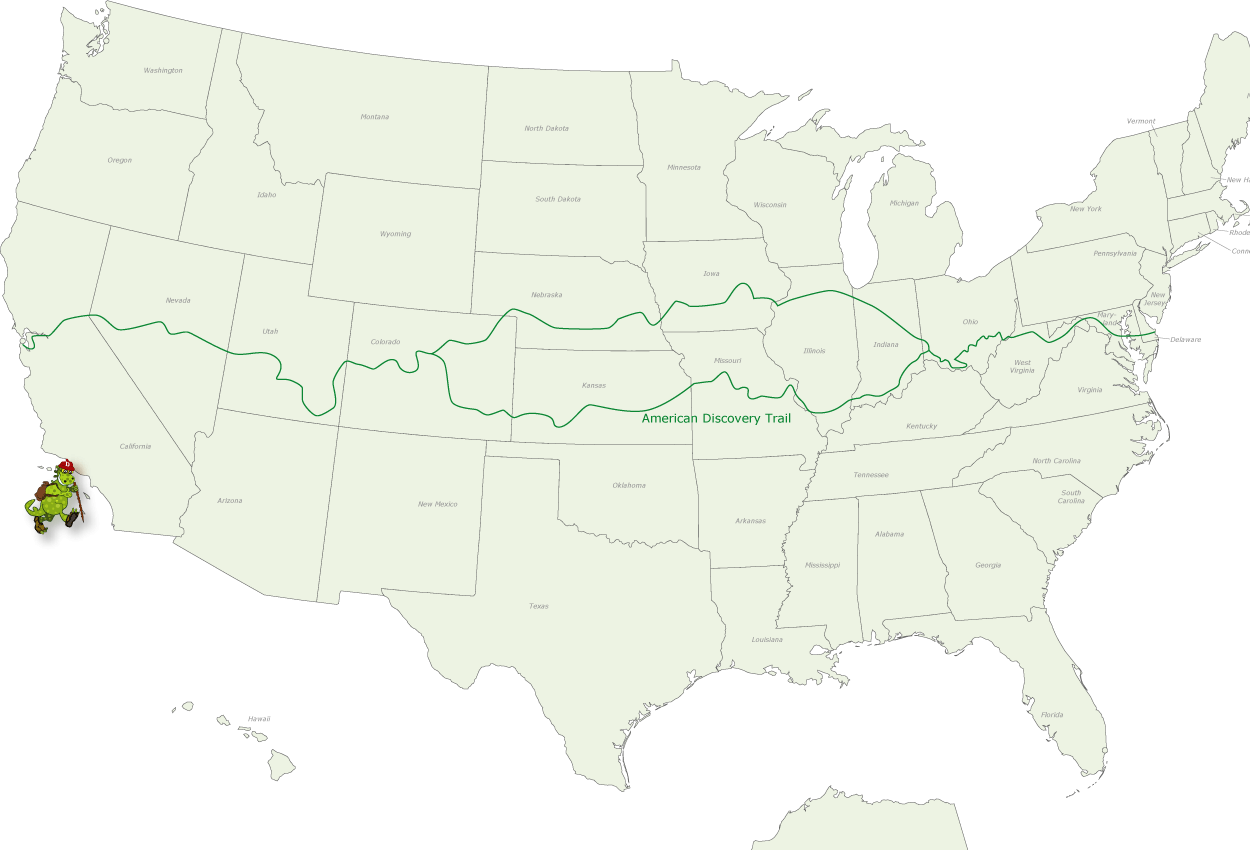
- Inicio de sendero Cape Henlopen State Park, Delaware
- Fin de sendero Point Reyes National Seashore, California
- Clasificación Traildino MW, Caminata moderada, sendero de mochileros
- Clasificación Travesía de refugios T1, Caminata
 You can hike or bike from coast to coast in just 5000 miles (8000 km) on this American Discovery Trail. Including the loops, the trail runs for 6356 miles (10,300 km) from Cape Henlopen State Park, Delaware westward to Point Reyes National Seashore, California. The trail combines many shorter and longer trails. The variety in landscape is enormous.
Select some tracks
☐American Discovery Trail, 1.2km
☐American Discovery Trail
☐American Discovery Trail, 1.6km
☐American Discovery Trail, 2km
☐American Discovery Trail, 1.3km
☐American Discovery Trail, 4.6km
☐American Discovery Trail
☐American Discovery Trail, 3.2km
☐American Discovery Trail, 5.4km
☐American Discovery Trail, 1.6km
☐American Discovery Trail, 0.7km
☐American Discovery Trail
☐American Discovery Trail
☐American Discovery Trail
☐American Discovery Trail
☐American Discovery Trail, 3.2km
☐American Discovery Trail, 2km
☐American Discovery Trail, 2.8km
☐American Discovery Trail, 5.3km
☐American Discovery Trail, 5.6km
☐American Discovery Trail, 7km
☐American Discovery Trail
☐American Discovery Trail, 6km
☐American Discovery Trail
☐American Discovery Trail, 2.8km
☐American Discovery Trail
☐American Discovery Trail, 1.9km
☐American Discovery Trail, 1.3km
☐American Discovery Trail
☐American Discovery Trail, 5.6km
☐American Discovery Trail
☐American Discovery Trail, 1.8km
☐American Discovery Trail
☐American Discovery Trail
☐American Discovery Trail, 0.8km
☐American Discovery Trail, 1.3km
☐American Discovery Trail, 5.9km
☐American Discovery Trail, 1.2km
☐American Discovery Trail
☐American Discovery Trail, 1.8km
☐American Discovery Trail, 3.3km
☐American Discovery Trail
☐American Discovery Trail, 2.3km
☐American Discovery Trail, 2.3km
☐American Discovery Trail, 6.8km
☐American Discovery Trail, 5.5km
☐American Discovery Trail, 1.6km
☐American Discovery Trail
☐American Discovery Trail, 2.2km
☐American Discovery Trail
☐American Discovery Trail, 2.6km
☐American Discovery Trail, 5.5km
☐American Discovery Trail, 1.6km
☐American Discovery Trail
☐American Discovery Trail, 1.4km
☐American Discovery Trail, 1km
☐American Discovery Trail
☐American Discovery Trail
☐American Discovery Trail, 0.8km
☐American Discovery Trail
☐American Discovery Trail, 0.9km
☐American Discovery Trail, 1.2km
☐American Discovery Trail, 1km
☐American Discovery Trail
☐American Discovery Trail, 1.7km
☐American Discovery Trail, 1.4km
☐American Discovery Trail, 1.9km
☐American Discovery Trail, 0.7km
☐American Discovery Trail, 2.3km
☐American Discovery Trail, 1.6km
☐American Discovery Trail, 0.7km
☐American Discovery Trail, 0.9km
☐American Discovery Trail
☐American Discovery Trail
☐American Discovery Trail
☐American Discovery Trail
☐American Discovery Trail, 1.4km
☐American Discovery Trail, 0.9km
☐American Discovery Trail, 1.2km
☐American Discovery Trail
☐American Discovery Trail, 0.8km
☐American Discovery Trail
☐American Discovery Trail
☐American Discovery Trail, 0.9km
☐American Discovery Trail, 0.4km
☐American Discovery Trail, 4.8km
☐American Discovery Trail, 1.4km
☐American Discovery Trail, 2.3km
☐American Discovery Trail, 3.9km
☐American Discovery Trail, 6.5km
☐American Discovery Trail
☐American Discovery Trail, 1km
☐American Discovery Trail, 6.6km
☐American Discovery Trail, 1.6km
☐American Discovery Trail, 10km
☐American Discovery Trail, 2.2km
☐American Discovery Trail, 2.1km
☐American Discovery Trail, 6.5km
☐American Discovery Trail, 3.7km
☐American Discovery Trail, 11km
☐American Discovery Trail, 6.1km
☐American Discovery Trail, 1km
☐American Discovery Trail, 3.1km
☐American Discovery Trail, 5.4km
☐American Discovery Trail, 2.8km
☐American Discovery Trail, 2km
☐American Discovery Trail, 11km
☐American Discovery Trail, 3.5km
☐American Discovery Trail, 7.2km
☐American Discovery Trail, 2.2km
☐American Discovery Trail
☐American Discovery Trail, 5km
☐American Discovery Trail, 7.2km
☐American Discovery Trail, 1.9km
☐American Discovery Trail, 2.9km
☐American Discovery Trail, 1.5km
☐American Discovery Trail, 6.4km
☐American Discovery Trail, 3.1km
☐American Discovery Trail, 2.5km
☐American Discovery Trail, 3.3km
☐American Discovery Trail, 0.4km
☐American Discovery Trail, 0.6km
☐American Discovery Trail, 2.5km
☐American Discovery Trail, 1.2km
☐American Discovery Trail, 1.4km
☐American Discovery Trail, 2.8km
☐American Discovery Trail, 5.8km
☐American Discovery Trail, 2.4km
☐American Discovery Trail, 1.1km
☐American Discovery Trail, 4.4km
☐American Discovery Trail, 6.5km
☐American Discovery Trail, 2.9km
☐American Discovery Trail, 1km
☐American Discovery Trail, 1.3km
☐American Discovery Trail
☐American Discovery Trail, 1.9km
☐American Discovery Trail
☐American Discovery Trail, 0.6km
☐American Discovery Trail, 5.3km
☐American Discovery Trail, 4.9km
☐American Discovery Trail
☐American Discovery Trail, 9.3km
☐American Discovery Trail, 3.6km
☐American Discovery Trail, 5.1km
☐American Discovery Trail
☐American Discovery Trail, 1km
☐American Discovery Trail, 3.9km
☐American Discovery Trail, 2.1km
☐American Discovery Trail, 2.4km
☐American Discovery Trail, 3.9km
☐American Discovery Trail, 7.2km
☐American Discovery Trail, 3km
☐American Discovery Trail, 3.2km
☐American Discovery Trail, 6.9km
☐American Discovery Trail, 1.6km
☐American Discovery Trail, 5.5km
☐American Discovery Trail, 3.2km
☐American Discovery Trail, 3.9km
☐American Discovery Trail, 2.4km
☐American Discovery Trail
☐American Discovery Trail, 1km
☐American Discovery Trail, 2km
☐American Discovery Trail
☐American Discovery Trail, 1.6km
☐American Discovery Trail
☐American Discovery Trail, 1.2km
☐American Discovery Trail
☐American Discovery Trail
☐American Discovery Trail
☐American Discovery Trail
☐American Discovery Trail, 3km
☐American Discovery Trail, 2.5km
☐American Discovery Trail, 0.9km
☐American Discovery Trail, 2km
☐American Discovery Trail
☐American Discovery Trail, 2.5km
☐American Discovery Trail, 5.2km
☐American Discovery Trail
☐American Discovery Trail, 1.4km
☐American Discovery Trail, 7.3km
☐American Discovery Trail, 2.7km
☐American Discovery Trail, 2.3km
☐American Discovery Trail, 1.5km
☐American Discovery Trail, 2.9km
☐American Discovery Trail, 1.4km
☐American Discovery Trail, 0.6km
☐American Discovery Trail, 1.4km
☐American Discovery Trail, 1km
☐American Discovery Trail, 1km
☐American Discovery Trail, 0.6km
☐American Discovery Trail, 0.8km
☐American Discovery Trail
☐American Discovery Trail, 1.2km
☐American Discovery Trail
☐American Discovery Trail
☐American Discovery Trail, 1.3km
☐American Discovery Trail, 3.7km
☐American Discovery Trail, 18km
☐American Discovery Trail, 8.7km
☐American Discovery Trail
☐Estação da Biodiversidade da Herdade de Ribeira Abaixo, 1.1km
Mapa
Enlaces
Datos
Informes
Guías y mapas
Hospedaje
Organizaciones
Operadores turísticos
GPS
Otro
Libros

Stanfords
United Kingdom
United Kingdom
- Waldviertel North - Gmund - Heidenreichstein - Waidhofen & Raabs a.d.T. - Trebon F&B WK075
- Waldviertel North - Gmünd - Heidenreichstein - Waidhofen a.d.T. - Raabs a.d.T. – Trebon area of eastern Austria presented at 1:50,000 in a series of contoured and GPS compatible outdoor leisure map from Freytag & Berndt with hiking and cycling routes, mountain huts, campsites and youth hostels, local bus stops, plus other tourist information.To... Leer más


