
Mundo
Descripción
Enlaces
Datos
Informes
Guías y mapas
Hospedaje
Organizaciones
Operadores turísticos
GPS
Otro
Libros

The Book Depository
United Kingdom
United Kingdom
- Wild Signs and Star Paths
- 52 keys that will open your eyes, ears and mind to the world around you Leer más


The Book Depository
United Kingdom
United Kingdom
- Great Hiking Trails of the World
- 80 Trails, 75,000 Miles, 38 Countries, 6 Continents Leer más

The Book Depository
United Kingdom
United Kingdom
- City Walks Edinburgh
- 15 short, fun and informative city walks bringing Edinburgh to life Leer más


The Book Depository
United Kingdom
United Kingdom
- The Secret World of Weather
- How to Read Signs in Every Cloud, Breeze, Hill, Street, Plant, Animal, and Dewdrop Leer más


The Book Depository
United Kingdom
United Kingdom
- Resilient Hope
- 100 Devotions for Building Endurance in an Unpredictable World Leer más

The Book Depository
United Kingdom
2013
United Kingdom
2013
- A Walk in the Clouds
- 75 short stories of adventures among the mountains of the world Leer más
Más libros…

Mapas

Stanfords
United Kingdom
United Kingdom
- Europe Children`s Placemat
- This is a colourful and resistant placemat by Little Wigwam, featuring a political map of Europe with capitals and major cities. All the information is up-to-date and includes Serbia, Kosovo and Montenegro. The seas are named, lines of longitude and latitude are shown at 15 degree intervals, the Arctic Circle is marked and the mat features a... Leer más
Stanfords
United Kingdom
United Kingdom
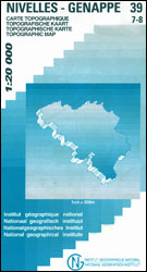
- Ans - Liège 20K NGI Belgium Survey Map No. 42/1-2
- Topographical survey of Belgium at 1:20,000 from Nationaal Geografisch Instituut / Institut Géographique National, the country’s national survey organization. Each 20K map covers one quarter of the corresponding 1:50,000 map (with adjustments in the border and coastal areas). The maps provide all the information expected of topographic mapping... Leer más
Stanfords
United Kingdom
United Kingdom
- Vise - St-Martens-Voeren
- Topographical survey of Belgium at 1:20,000 from Nationaal Geografisch Instituut / Institut Géographique National, the country’s national survey organization. Each 20K map covers one quarter of the corresponding 1:50,000 map (with adjustments in the border and coastal areas). The maps provide all the information expected of topographic mapping... Leer más
Stanfords
United Kingdom
United Kingdom
- Dalhem - Herve
- Topographical survey of Belgium at 1:20,000 from Nationaal Geografisch Instituut / Institut Géographique National, the country’s national survey organization. Each 20K map covers one quarter of the corresponding 1:50,000 map (with adjustments in the border and coastal areas). The maps provide all the information expected of topographic mapping... Leer más

Stanfords
United Kingdom
United Kingdom
- Durban MapStudio Pocket Map
- Central Durban at 1:12,500 on an indexed street plan from the South African map publishers, Map Studio, with on the reverse a road map of the city’s environs at 1:100,000, plus a plan of the uShaka Marine World. Also included is a list of renamed streets giving both the old and the new names, plus on the plan itself newly assigned street names... Leer más
Stanfords
United Kingdom
United Kingdom
- Quievrain - Boussu
- Topographical survey of Belgium at 1:20,000 from Nationaal Geografisch Instituut / Institut Géographique National, the country’s national survey organization. Each 20K map covers one quarter of the corresponding 1:50,000 map (with adjustments in the border and coastal areas). The maps provide all the information expected of topographic mapping... Leer más
Stanfords
United Kingdom
United Kingdom
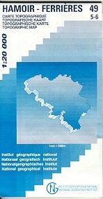
- Hamoir - Ferrieres
- Topographical survey of Belgium at 1:20,000 from Nationaal Geografisch Instituut / Institut Géographique National, the country’s national survey organization. Each 20K map covers one quarter of the corresponding 1:50,000 map (with adjustments in the border and coastal areas). The maps provide all the information expected of topographic mapping... Leer más
Stanfords
United Kingdom
United Kingdom
- Vresse-sur-Semois
- Topographical survey of Belgium at 1:20,000 from Nationaal Geografisch Instituut / Institut Géographique National, the country’s national survey organization. Each 20K map covers one quarter of the corresponding 1:50,000 map (with adjustments in the border and coastal areas). The maps provide all the information expected of topographic mapping... Leer más

Stanfords
United Kingdom
United Kingdom
- Barcelona - Zaragoza - Castellón de la Plana 500K CNIG Regional Map No. 7
- The Mediterranean coast of Spain between Barcelona and Castellón de la Plana, extending west to Zaragoza and Teruel, at 1:500,000 in a series of regional road maps from the country’s civilian survey organization IGN-CNIG (Instituto Geográfico Nacional - Centro Nacional de Información Geográfica), vividly presenting the topography by altitude... Leer más


Stanfords
United Kingdom
United Kingdom
- Aurlandsfjellet Nordeca Tourist Route 20005
- This Aurlandsfjellet National Tourist Route Map belongs to a series of 18 map and postcards sets describing popular tourist routes all over Norway. The map set includes a map in 1: 50,000 presenting an accurate topography (based on the Norwegian topographic survey) which describes local footpaths, cycle or ski routes, sport and recreational... Leer más

Stanfords
United Kingdom
United Kingdom
- Kieldrecht- Doel
- Topographical survey of Belgium at 1:20,000 from Nationaal Geografisch Instituut / Institut Géographique National, the country’s national survey organization. Each 20K map covers one quarter of the corresponding 1:50,000 map (with adjustments in the border and coastal areas). The maps provide all the information expected of topographic mapping... Leer más
Stanfords
United Kingdom
United Kingdom
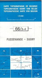
- Pussemange - Sugny
- Topographical survey of Belgium at 1:20,000 from Nationaal Geografisch Instituut / Institut Géographique National, the country’s national survey organization. Each 20K map covers one quarter of the corresponding 1:50,000 map (with adjustments in the border and coastal areas). The maps provide all the information expected of topographic mapping... Leer más

Stanfords
United Kingdom
United Kingdom
- Seraing - Chaudfontaine
- Topographical survey of Belgium at 1:20,000 from Nationaal Geografisch Instituut / Institut Géographique National, the country’s national survey organization. Each 20K map covers one quarter of the corresponding 1:50,000 map (with adjustments in the border and coastal areas). The maps provide all the information expected of topographic mapping... Leer más

Stanfords
United Kingdom
United Kingdom
- Monde Connu en 1688 par Jaugeon
- High quality reproduction from the IGN of a beautifully engraved map of the world prepared in 1688 by Jacques Jaugeon, French scholar and royal typographer during the reign of King Louis XIV. The map presents the world in two hemispheres, surrounded by allegorical figures representing the constellations and definitions of geographical terms... Leer más