Alsterwanderweg
Descripción
- Name Alsterwanderweg
- Distancia de sendero 37 km, 23 millas
- Duración en días 2 días
- Inicio de sendero Source of Alster
- Fin de sendero Mouth of Alster
- Clasificación Traildino LW, Paseo ligero, paseo en entorno campestre


37 km. Along the river Alster, from source to mouth.
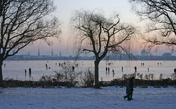
For the inhabitants of Hamburg, the Alsterwanderweg is a pleasant trip away from the busy city life. The Alster is a river that is born north of the metropolis and flows to the south into the Elbe. Its course is marked by dense forest most of the time, although the outskirts of the city are never far away. Near the center of Hamburg, the river turns into a lake, popular with the locals.
Select some tracks
☐Kayhude - Poppenbüttel (K-P) Alsterwanderweg, 15km
Enlaces
Datos
- Alsterwanderweg - Away from civilization and back! | Hamburg Spotted by Locals
An English introduction to the trail.
- Alsterwanderweg an der Alster - Hamburg Web (Alemán)
Intro from Hamburg Webguide.
- Alsterwanderweg – Wikipedia (Alemán)
- Alsterwanderweg wandern in Hamburg Wanderwege Infos und Tipps für Wanderer - Wandern & Outdoor.de (Alemán)
Intro, map and GPS file.
Informes
- Alsterwanderweg (Alemán)
Picture set of the Alster Wanderweg in winter.
- Alsterwanderweg Mai 2008 (Alemán)
And a picture story of a part of the trail.
- Der Weg ist das Ziel: Der Alsterwanderweg (Alemán)
Short blog, XML file of part of the trail
- Hamburg Alsterwanderweg (Alemán)
Another picture set: autumn.
Guías y mapas
Hospedaje
Organizaciones
Operadores turísticos
GPS
Otro
Mapas

De Zwerver
Netherlands
Netherlands
- Wandelkaart 725 Hamburg | Kompass
- Goede wandelkaart met vrijwel alle topografische details als hoogtelijnen, vegetatie, schaduwtekening maar ook de ingetekende wandelroutes en in veel gevallen ook fietsroutes (MTB). Gevaarlijke routes worden als zodanig weergegeven met een bepaalde markering. Berghutten en campings zijn goed terug te vinden op deze kaarten. Daarnaast staan de... Leer más