República Centroafricana
Descripción
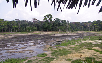
The Central African Republic is a landlocked country right in the middle of Africa. It is relatively flat to hilly savanna, with some desert in the north, some tropical rainforest in the south.
There are a number of national parks, such as Manovo-Gounda-Saint-Floris in the northeast, with the greatest concentrations of hippos in the world. There are also Bamingui-Bangoran in the north; and Dzanga-Sangha in the southwest.
Regiones
Enlaces
Datos
Informes
Guías y mapas
Hospedaje
Organizaciones
Operadores turísticos
GPS
Otro
Libros

Bol.com
Netherlands
Netherlands
- An African Adventure Atlas
- This text divides the African continent into 15 geographical regions which are introduced over 30 pages and serve to lead the reader into the sections of the atlas, comprising National Parks, town plans and adventure activities. For ease of reference, colour-coded "tabs" clearly identify the different secitons, which include: Morocco and the... Leer más
- Also available from:
- Bol.com, Belgium

Bol.com
Belgium
Belgium
- An African Adventure Atlas
- This text divides the African continent into 15 geographical regions which are introduced over 30 pages and serve to lead the reader into the sections of the atlas, comprising National Parks, town plans and adventure activities. For ease of reference, colour-coded "tabs" clearly identify the different secitons, which include: Morocco and the... Leer más
Mapas

Stanfords
United Kingdom
United Kingdom
- Central African Republic IGN 85011
- Indexed map with a plan of Bangui and an administrative map of the country. Topography and terrain are indicated by relief shading and spot heights, with forests, savanna, deserts, areas of seasonal inundation, and boundaries of national parks and forest reserves. Road network includes minor roads and tracks and shows location of petrol... Leer más

De Zwerver
Netherlands
2012
Netherlands
2012
- Wegenkaart - landkaart Kongo - CAR, Democratic Republic of Congo & Central African Republic | ITMB
- Carte routière en couleur utile pour les voyageurs. Textes en anglais uniquement. Leer más


