Pyrenees
Descripción
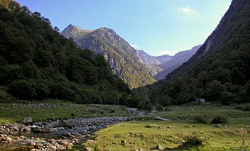
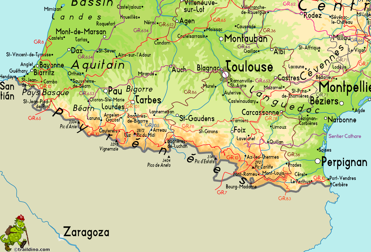
The Pyrenees form the natural border between Spain and france. The mountain range extends from one sea to the other, from the Atlantic to the Mediterranean, always a good excuse for hikers to symbolically cross over and stay away from home two months.
Of course there is a fan group of the Pyrenees versus one of the Alps. The Pyrenees are very different from the Alps alltogether. There are no large lakes, but many high situated small ones. There are almost no passings over the Pyrenees from France into Spain. The famous exceptions - St Jean-Pied-de-Port and Col de Somport - are used by the Way of St. James, Camino de Santiago.
There are plenty of good hikes, among them the GR10, the Haute Randonnée Pyrénéenne, and - on the Spanish side, the GR11.
Mapa
Senderos en región
- Camino AragonésGPX
- Camino de BaztanGPX
- Camino de GironaGPX
- Camino FrancésGPX
- Carros de FocGPX
- E3GPX
- E4GPX
- E7GPX
- GR10 - Traversée des PyrénéesGPX
- GR101GPX
- GR107 - El Camí dels Bons HomesGPX
- GR11 Sendero PirenaicoGPX
- GR36 - Traversée du PérigordGPX
- GR65 - Via PodiensisGPX
- GR7GPX
- GR78 - Sentier de PiémontGPX
- GR8GPX
- GR83 - Camí del Nord o del CanigóGPX
- GR86GPX
- HRP - Haute Randonnée PyrénéenneGPX
- Sentier CathareGPX
- Tour du LarzacGPX
- Voie de Lourdes
- Voie du PiémontGPX
Enlaces
Datos
Informes
Guías y mapas
Hospedaje
Organizaciones
Operadores turísticos
GPS
Otro
Libros

United Kingdom
- Taga - Serra Cavallera Editorial Alpina
- Taga – Serra Cavalara area in the eastern part of the Spanish Pyrenees on a contoured and GPS compatible map at 1:25,000 from Editorial Alpina, highlighting local and long-distance hiking trails, accommodation facilities, etc.The map has contour lines at 10m intervals enhanced by relief shading, plus colouring to indicate different types of... Leer más

United Kingdom
2020
- Les Abers - le Chemin de Phares GR34/GR34F
- Les Abers - le chemin de phares, FFRP topoguide Ref. no. 347, covering the coastal route in north-western Brittany between Morlaix, Brest, and le Fau, plus 4 walks on the Ile d`Ouessant. Current edition of this title was published in September 2017.Between Morlaix and Brest, where the sea has dug deep furrows in the land. More than 20 days of... Leer más

United Kingdom
2012
- Haute Vallée de l`Aube à pied FFRP Topo-guide No. P112
- Haute Vallée de l`Aube à pied, FFRP topo-guide ref. no. P112, one of the titles in an extensive series of light, A5-size, high quality paperback guides published by the Fédération Française de la Randonnée Pédestre in association with local authorities, ramblers’ clubs, etc. The guides have *colour extracts from the French topographic survey at... Leer más

United Kingdom
2019
- Les Hautes-Pyrénées à pied
- Les Hautes-Pyrénées à pied, FFRP topo-guide Ref. No. D065, with 45 day walks of varying length and difficulty in the heart of the French Pyrenees, from north of Tarbes to the Pyrenees National Park near Gavarnie. Current edition of this title was published in February 2016.To see the list of other FFRP guides with day walks please click on the... Leer más

United Kingdom
2020
- Loudenvielle at la vallée du Louron à pied ST06
- Loudenvielle at la vallée du Louron à pied, FFRP topo-guide Ref. No.ST06, with 20 day walks of varying length and difficulty near Loudenvielle in the French Pyrenees. Each walk is presented on a separate colour extract from IGN’s topographic survey of France at 1:25,000, with its description cross-referenced to the map. Current edition of this... Leer más

United Kingdom
2018
- Les Pyrénées Orientales à pied D066
- Les Pyrénées Orientales à pied, FFRP topo-guide Ref. No. D066, with 25 day walks of varying length and difficulty in the department of Pyrénées Orientales on the Mediterranean end of the mountain chain. Each walk is presented on a separate colour extract from IGN’s topographic survey of France at 1:25,000, with its description cross-referenced... Leer más

United Kingdom
- GR3: Les Monts du Forez FFRP Topo-guide No. 334
- Les Monts du Forez, FFRP topoguide Ref. No. 334, covering in all 259kms along the GR3 and its variant, with additional descriptions of 21 day walks in the region. Current edition of this title was published in April 2016.ABOUT THE FFRP (Fédération française de la randonnée pédestre) TOPOGUIDES: published in a handy A5 paperback format, the... Leer más

United Kingdom
- Call of the Camino
- The experiences of an ordinary man on the pilgrim`s path are charted in this narrative that walks along the Camino Frances to the shrine of Saint James at Santiago de Compostela and then on to Finisterre, the westernmost point of Spain. The history of the Camino is recounted, as well as several of the myths, legends, and miracle stories that... Leer más

United Kingdom
- A Cyclist`s Guide to the Pyrenees
- Where do you turn when you want to ride in the mountains, to follow in the wheeltracks of professional racers by climbing the famous passes of the Tour de France? There are several books and websites that highlight these renowned ascents, detailing their location, length and every little change in gradient. But how do you go about finding a... Leer más

United Kingdom
- DK Eyewitness Spain
- Discover Spain - a compelling country filled with must-see sightsWhether you want to explore Granada`s spectacular Alhambra palace, watch swirling flamenco dancers in Seville or walk through lush countryside on the epic Camino de Santiago, your DK Eyewitness travel guide makes sure you experience all that Spain has to offer.From the golden... Leer más

United Kingdom
2016
- Pyrenees: Car Tours and Walks
- Pyrenees is the Sunflower Landscapes guide to exploring the best walking and touring possibilities in the mountain range. The guide covers a range of routes including walks in Vilajuiga, Pedraforca, the Anisclo Canyon and Roncesvalles. A double-sided, fold-out touring map at the back of the book gives an overview of the region and the locations... Leer más

United Kingdom
2021
- Camino de Santiago: The ancient Way of Saint James pilgrimage route from the French Pyrenees to Santiago de Compostela
- El Camino de Santiago de Compostela, the ancient Christian pilgrimage route has been travelled for over a thousand years to the Cathedral of Santiago de Compostela, where, legend has it, the bones of St James are buried. This guide follows the most popular route, starting at St Jean-Pied-de-Port in south-west France and heading all the way... Leer más

United Kingdom
2018
- Val d`Azun à pied ST10
- Val d`Azun à pied, FFRP topo-guide Ref. No. ST10, with 18 day walks of varying length and difficulty in the French Pyrenees south-west of Argelès-Gazost, plus a tour which includes part of the GR10 long-distance footpaths. Each walk is presented on a separate colour extract from IGN’s topographic survey of France at 1:25,000 and/or 1:50,000,... Leer más

United Kingdom
2020
- Tour du Larzac, Templier - Hospitalier - Entre causses et vallées GR71C/GR71D
- Tour du Larzac - Templier et Hospitalier, FFRP topoguide Ref. No. 710, covering the 195kms of hiking circuits along the GR71C and GR71D south of Millau in the Causse du Larzac, plus 13 local day walks. Current edition of this title was published in December 2015.ABOUT THE FFRP (Fédération française de la randonnée pédestre) TOPOGUIDES:... Leer más

United Kingdom
- St-Lary-Soulan et la Vallée d`Aure à pied ST07
- Saint-Lary-Soulan et la vallée d`Aure à pied, FFRP topo-guide Ref. No. ST07, with 25 day walks of varying length and difficulty in the French Pyrenees. Each walk is presented on a separate colour extract from IGN’s topographic survey of France at 1:25,000, with its description cross-referenced to the map. Current edition of this title was... Leer más
Mapas

United Kingdom
- Ordesa - Monte Perdido National Park Editorial Alpina 2-Map Set
- Ordesa and Monte Perdido National Park at 1:25,000 in a set of two GPS compatible recreational maps in an extensive and very popular series from Editorial Alpina, providing more detailed coverage of this popular hiking area.Contours are at 10m intervals, with relief shading and vegetation colouring. An overprint highlights waymarked PR hiking... Leer más

United Kingdom
- Costabona - Alta Val de Ter Editorial Alpina
- Costabona - Alta Val de Ter area of the Catalan Pyrenees on a contoured and GPS compatible map at 1:25,000 from Editorial Alpina, highlighting hiking trails, campsites and refuges, etc. Topography is shown by contours at 10m intervals with relief shading and numerous spot heights, plus colouring for woodlands, brushwood, meadows and farmland.... Leer más

United Kingdom
- Alt Pirineu Natural Park Editorial Alpina
- Alt Pirineu Natural Park in the Catalan Pyrenees on a contoured and GPS compatible map at 1:50,000 from Editorial Alpina. Coverage extends northwards from La Seu d’Urgell and Sort beyond the French border to Aulus-les-Bains. Accompanying booklet includes an extensive list of contact details for various types of local accommodation.The map has... Leer más

United Kingdom
- Bachimala - Valles de Chistau y Bielsa Editorial Alpina
- Bachimala area of the High Pyrenees in Spain on a contoured and GPS compatible map at 1:25,000 from Editorial Alpina, with a booklet including English language descriptions of recommended walks, extensive accommodation list, etc. With the peak of Gran Bachimala towards the north-eastern corner of the map, coverage extends west to Bielsa and... Leer más

United Kingdom
2016
- Le Languedoc-Roussillon à pied FFRP Topo-guide No. RE13
- Le Languedoc-Roussillon à pied, FFRP topo-guide Ref. No. RE13, with 50 day walks in the some of the most visited departments in France: Lozère, Gard, Hérault, Aude and Pyrénées Orientales which include Mende, Alès, Nîmes, Montpellier, Béziers, Narbonne, Carcassonne and Perpignan. Each day walk is presented on a separate colour extract from... Leer más

United Kingdom
- Garrotxa - Zona Volcanica Editorial Alpina
- Garrotxa Volcanic Zone Natural Park near Olot in the Catalan Pyrenees on a contoured and GPS-compatible map at 1:25,000 from Editoral Alpina, highlighting local and long-distance hiking trails, etc, plus a booklet with 26 pages in English providing descriptions of 11 recommended local walks, etc.The map has contours at 10m intervals with relief... Leer más

United Kingdom
- Bregenz F&B
- Indexed street plan of Bregenz extending north along the Bodensee coast to Lochau and Unter Hochsteg. Detail includes pedestrianised areas, railways, bus routes and cycle paths. Notable buildings are highlighted in red, and symbols indicate post offices, hostels, campsites and car parks.On the reverse is a 1:50,000 contoured map of the... Leer más

United Kingdom
- Massif du Canigou / Massis del Canigo IGN 2349ET
- Topographic survey of France at 1:25,000 in IGN`s excellent TOP25 / Série Bleue series. All the maps are GPS compatible, with a 1km UTM grid plus latitude and longitude lines at 5’ intervals. Contours are at 5m intervals except for mountainous areas where the maps have contours at 10m intervals, vividly enhanced by hill shading and graphics for... Leer más

United Kingdom
- Pays Basque West Rando Editions 1 SUPERCEDED
- The westernmost section of the French Pyrenees between the Atlantic coast and St-Jean-Pied-de-Port on a contoured and GPS compatible map at 1:50,000 from Rando Editions with topographic base provided by the IGN, highlighting local and long-distance hiking trails, cycle and mountain bike routes, etc. Coverage along the Atlantic coast starts at... Leer más

United Kingdom
- Ile d`Oléron - Ile de Ré Rando Editions
- Ile d’Oléron, Ile de Ré and the nearby mainland, including La Rochelle, Rochefort and the surrounding marshes, on a detailed topographic map at 1:50,000 from Rando Editions with cartography from the IGN, hiking and cycling routes, etc.The map, intended to be the first in a series of titles covering the Atlantic coast of France, is overprinted... Leer más

United Kingdom
- Laruns - Gourette - Col d`Aubisque - Vallee d`Ossau IGN 1546ET
- Topographic survey of France at 1:25,000 in IGN`s excellent TOP25 / Série Bleue series. All the maps are GPS compatible, with a 1km UTM grid plus latitude and longitude lines at 5’ intervals. Contours are at 5m intervals except for mountainous areas where the maps have contours at 10m intervals, vividly enhanced by hill shading and graphics for... Leer más

United Kingdom
- Oloron-Saint-Marie - Vallee d`Aspe IGN 1546OT
- Topographic survey of France at 1:25,000 in IGN`s excellent TOP25 / Série Bleue series. All the maps are GPS compatible, with a 1km UTM grid plus latitude and longitude lines at 5’ intervals. Contours are at 5m intervals except for mountainous areas where the maps have contours at 10m intervals, vividly enhanced by hill shading and graphics for... Leer más

United Kingdom
2016
- Sur les Traces des Cathares GR107 FR et ES Plus de 10 Jours de Randonnee: FFR.1097: 2016
- Sur les traces des Cathares, Le Chemin des Bonshommes GR 10 Topo Guide FFRP ref 1097 Hiking guide for the French Pyrenees with description of a multi-day hike of 220 km for 10 days hiking through the Cathar country from Foix, Ariege along Andorra to Berga ( Pyrenees France and Spain).French-speaking hiking guide. Excellent description with... Leer más

United Kingdom
- Biarritz - Bayonne - Anglet and their Environs IGN 88415
- Biarritz - Bayonne - Anglet and their Environs in a series of detailed road maps at 1:80,000 from the IGN, designed to highlight places of interest and recreational possibilities, with a city centre street plan and an enlargement of a selected hiking area.Cartography is an enlargement from 1:100,000 to 1:80,000 of the publisher’s highly popular... Leer más

United Kingdom
- Bagneres-de-Luchon - Lac d`Oo IGN WATERPROOF 1848OTR
- Topographic survey of France at 1:25,000 in IGN`s excellent TOP25 / Série Bleue series. All the maps are GPS compatible, with a 1km UTM grid plus latitude and longitude lines at 5’ intervals. Contours are at 5m intervals except for mountainous areas where the maps have contours at 10m intervals, vividly enhanced by hill shading and graphics for... Leer más


