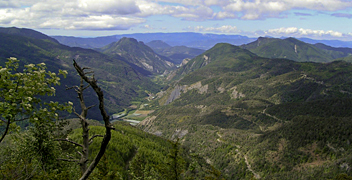
GR653D - Voie d’Arles
Descripción
- Name GR653D - Voie d’Arles (GR653D)
- Distancia de sendero 430 km, 267 millas
- Duración en días 17 días
- Inicio de sendero Col de Montgenevre
- Fin de sendero Arles
- Clasificación Traildino MW, Caminata moderada, sendero de mochileros
- Clasificación Travesía de refugios T1, Caminata
Via Domitia or GR653 - Voie d’Arles, Col de Montgenevre - Arles, 430 km, 17 days
The Romans constructed this way to connect - what is now - Italy and Spain through France. The itinerary is still known, and at places, Roman constructions are still in place.
The trail is revived as a possible route to Santiago de Compostela. Also, the trail - more or less following the ancient road - is described in a topoguide as GR 653D, Voie d’Arles.
The first part of the trail traverses the Hautes-Alpes. The walk has an alpine character. Between Gap and Apt, it follows the River Durance. Leaving Apt, it is the Provence you are walking through. Finally, in Arles, the trail ends.
Pilgrims then continue on the Via Tolosana, one of the main Ways of St. James in France, heading for the Pyrenees and Spain.
Visit Traildino's overview page for the Way of Saint James / Camino de Santiago.
Enlaces
Datos
Informes
Guías y mapas
Hospedaje
Organizaciones
Operadores turísticos
GPS
Otro
Libros

United Kingdom
- The Way of Saint James Along the Via Domitia
- A Travel Guide and a Journey of Love from Oulx to Arles Leer más

Netherlands
2014
- Wandelgids - Pelgrimsroute 6531 Sentier vers Saint-Jacques-de-Compostelle : Montgenèvre - Arles GR653D | FFRP
- Guide FFRandonnée Sentier vers Saint-Jacques-de-Compostelle : Montgenèvre - Arles - GR 653D - 459 km de sentiers GR. La Voie d'Arles. Un chemin incontournable, à la fois itinéraire jacquaire et ancienne voie romaine, qui vous fera découvrir 4 départements aux paysages contrastés et au... Leer más


