
Stanfords
United Kingdom
- Serra de Montsant Editorial Piolet Hiking Map
- Serra de Montsant area at 1:20,000 in a series of GPS compatible maps from Editorial Piolet with cartography based on Spain’s civilian topographic survey overprinted with hiking routes and other tourist information. The overprint includes 11 recommended itinerates in the park, plus eight special walks exploring local flora.Hiking maps in the... Leer más
Stanfords
United Kingdom
- Bachimala - Valles de Chistau y Bielsa Editorial Alpina
- Bachimala area of the High Pyrenees in Spain on a contoured and GPS compatible map at 1:25,000 from Editorial Alpina, with a booklet including English language descriptions of recommended walks, extensive accommodation list, etc. With the peak of Gran Bachimala towards the north-eastern corner of the map, coverage extends west to Bielsa and... Leer más

Stanfords
United Kingdom
- La Tablas de Daimiel National Park CNIG Map-Guide SPANISH
- La Tablas de Daimiel National Park north of Ciudad Real on a large, double-sided, contoured and GPS compatible map at 1:25,000 on a from IGN/CNIG with cartography from their topographic survey of Spain. The central part of the map, the swamps between the Guadiana and Gigüela Rivers, is shown enlarged on a satellite image indicating access from... Leer más

Stanfords
United Kingdom
- Alt Pirineu Natural Park Editorial Alpina
- Alt Pirineu Natural Park in the Catalan Pyrenees on a contoured and GPS compatible map at 1:50,000 from Editorial Alpina. Coverage extends northwards from La Seu d’Urgell and Sort beyond the French border to Aulus-les-Bains. Accompanying booklet includes an extensive list of contact details for various types of local accommodation.The map has... Leer más

Stanfords
United Kingdom
- Cap de Creus Park Natural Editorial Alpina
- Cap de Creus Natural Park on the Costa Brava at 1:25,000 on a contoured and GPS compatible map from Editorial Alpina, plus a booklet which includes English language descriptions several recommended hiking trails, accommodation details, etc.Topography is presented by contours at10m intervals with relief shading and plenty of spot heights, plus... Leer más

Stanfords
United Kingdom
- Costabona - Alta Val de Ter Editorial Alpina
- Costabona - Alta Val de Ter area of the Catalan Pyrenees on a contoured and GPS compatible map at 1:25,000 from Editorial Alpina, highlighting hiking trails, campsites and refuges, etc. Topography is shown by contours at 10m intervals with relief shading and numerous spot heights, plus colouring for woodlands, brushwood, meadows and farmland.... Leer más

Stanfords
United Kingdom
- Garrotxa - Zona Volcanica Editorial Alpina
- Garrotxa Volcanic Zone Natural Park near Olot in the Catalan Pyrenees on a contoured and GPS-compatible map at 1:25,000 from Editoral Alpina, highlighting local and long-distance hiking trails, etc, plus a booklet with 26 pages in English providing descriptions of 11 recommended local walks, etc.The map has contours at 10m intervals with relief... Leer más

Stanfords
United Kingdom
- Cilleruelo de Abajo CNIG Topo 314
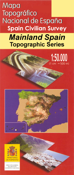
- Topographic coverage of mainland Spain at 1:50,000 in the MTN50 (Mapa Topográfico Nacional) series from the Centro Nacional de Información Geografica, the country’s civilian survey organization. The maps have contours at 20m intervals, enhanced by relief shading, plus colouring and/or graphics to show different types of terrain, vegetation or... Leer más

Stanfords
United Kingdom
- Chineneas CNIG Topographic Map 1026-I
- Topographic coverage of mainland Spain at 1:25,000 published by the Centro Nacional de Información Geograficá, the country’s civilian survey organization. The maps have contours at 10m intervals and colouring and/or graphics to show different types of vegetation or land use. Boundaries of national parks and other protected areas are marked. In... Leer más

Stanfords
United Kingdom
- Siguüeiro CNIG Topo 95
- Topographic coverage of mainland Spain at 1:50,000 in the MTN50 (Mapa Topográfico Nacional) series from the Centro Nacional de Información Geografica, the country’s civilian survey organization. The maps have contours at 20m intervals, enhanced by relief shading, plus colouring and/or graphics to show different types of terrain, vegetation or... Leer más
Stanfords
United Kingdom
- Hueneja CNIG Topographic Map 1011-IV
- Topographic coverage of mainland Spain at 1:25,000 published by the Centro Nacional de Información Geograficá, the country’s civilian survey organization. The maps have contours at 10m intervals and colouring and/or graphics to show different types of vegetation or land use. Boundaries of national parks and other protected areas are marked. In... Leer más
Stanfords
United Kingdom
- Alhama de Almeria CNIG Topo 1044
- Topographic coverage of mainland Spain at 1:50,000 in the MTN50 (Mapa Topográfico Nacional) series from the Centro Nacional de Información Geografica, the country’s civilian survey organization. The maps have contours at 20m intervals, enhanced by relief shading, plus colouring and/or graphics to show different types of terrain, vegetation or... Leer más
Stanfords
United Kingdom
- Garrucha CNIG Topographic Map 1015-III
- Topographic coverage of mainland Spain at 1:25,000 published by the Centro Nacional de Información Geograficá, the country’s civilian survey organization. The maps have contours at 10m intervals and colouring and/or graphics to show different types of vegetation or land use. Boundaries of national parks and other protected areas are marked. In... Leer más
Stanfords
United Kingdom
- Lanjaron CNIG Topo 1042-1
- Topographic coverage of mainland Spain at 1:25,000 published by the Centro Nacional de Información Geograficá, the country’s civilian survey organization. The maps have contours at 10m intervals and colouring and/or graphics to show different types of vegetation or land use. Boundaries of national parks and other protected areas are marked. In... Leer más
Stanfords
United Kingdom
- Cortes de la Frontera CNIG Topographic Map 1064-II
- Topographic coverage of mainland Spain at 1:25,000 published by the Centro Nacional de Información Geograficá, the country’s civilian survey organization. The maps have contours at 10m intervals and colouring and/or graphics to show different types of vegetation or land use. Boundaries of national parks and other protected areas are marked. In... Leer más