
Isle of Man Coastal Path
Descripción
- Name Isle of Man Coastal Path
- Distancia de sendero 153 km, 95 millas
- Duración en días 8 días
- Clasificación Traildino EW, Paseo fácil, sendero en la naturaleza
Isle of Man Coastal Path, Raad ny Foillan, The Way of the Gull, 95 miles, 153 km
Circular trail on the Isle of Man, generally following the coastline. Good walk in spring for seabirds lovers. A true walkers paradise.
Select some tracks
☐Raad Ny Foillan, 158km
Enlaces
Datos
Informes
Guías y mapas
Hospedaje
Organizaciones
Operadores turísticos
GPS
Otro
Libros

Stanfords
United Kingdom
2015
United Kingdom
2015
- Isle of Man Walking
- 40 half to full day walks on the coast and fells of the Isle of Man are explored in this guide book. Most of the walks are short and accessible for walkers of all abilities. For walkers looking for a greater challenge, there are longer adventures and plenty of opportunities to combine routes. Walking on the Isle of Man is a clear demonstration... Leer más

Stanfords
United Kingdom
2018
United Kingdom
2018
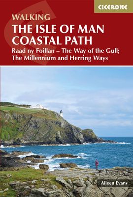
- Isle of Man Coastal Path - with the Millennium & Herring Ways
- Raad ny Foillan (The Way of the Gull) is a 98 mile footpath around the Isle of Man. The route description is set out as a circuit and split into stages, with the longest walk being 15.5 miles and the shortest being 7 miles. Any fast walkers may wish to complete two stages per day, while those progressing at a more leisurely pace may decide to... Leer más
- Also available from:
- The Book Depository, United Kingdom
- Bol.com, Netherlands
- Bol.com, Belgium
- De Zwerver, Netherlands

The Book Depository
United Kingdom
2018
United Kingdom
2018
- Isle of Man Coastal Path
- Raad Ny Foillan - The Way of the Gull; The Millennium and Herring Ways Leer más
Bol.com
Netherlands
2018
Netherlands
2018
- Isle of Man Coastal Path
- This handy guidebook describes the 98 mile Isle of Man coastal path, Raad ny Foillan. The route never strays far from the sea and boasts spectacular scenery, from rugged sea cliffs and mountain moorland to beaches and glens. The Raad ny Foillan path can be completed in about a week. The Milennium Way and the Herring Way are also described. Leer más
Bol.com
Belgium
2018
Belgium
2018
- Isle of Man Coastal Path
- This handy guidebook describes the 98 mile Isle of Man coastal path, Raad ny Foillan. The route never strays far from the sea and boasts spectacular scenery, from rugged sea cliffs and mountain moorland to beaches and glens. The Raad ny Foillan path can be completed in about a week. The Milennium Way and the Herring Way are also described. Leer más
De Zwerver
Netherlands
2018
Netherlands
2018
- Wandelgids Walking guide Isle of Man Coastal Path | Cicerone
- Guidebook to walking the Isle of Man coastal path, the Way of the Gull (Raad ny Foillan). The spectacular 98 mile route is described in 9 stages and takes in beaches, glens, moorland and rugged sea cliffs. It can be walked in around a week. Two other paths, the Millennium Way (Bayr ny Ree) and the Herring Way (Bayr ny Skeddan), are also described. Leer más
Mapas

Stanfords
United Kingdom
United Kingdom
- Isle of Man 1874
- Map No. 95, Isle of Man 1874, in the Cassini Historical Series of old Ordnance Survey mapping of England and Wales at 1:50,000 in a format designed to offer a convenient comparison with the present day coverage from the OS, and most locations in three different editions. Old historical maps have been combined so that the sheet lines correspond... Leer más
Stanfords
United Kingdom
United Kingdom
- Isle of Man 1921
- Map No. 95, Isle of Man 1925, in the Cassini Historical Series of old Ordnance Survey mapping of England and Wales at 1:50,000 in a format designed to offer a convenient comparison with the present day coverage from the OS, and most locations in three different editions. Old historical maps have been combined so that the sheet lines correspond... Leer más