
London
Descripción
Capital of the United Kingdom. All sorts of walks. The Thames Path runs right through the city center and you can hop on the London Eye after being fooled at the ticket counter and view forward and backward on your trail.
Senderos en región
Enlaces
Datos
Informes
Guías y mapas
Hospedaje
Organizaciones
Operadores turísticos
GPS
Otro
Libros

Stanfords
United Kingdom
United Kingdom
- An Opinionated Guide To London Green Spaces
- Don`t be fooled by London`s concrete landscape: it is, in fact, one of the greenest cities in the world. This small paperback featuring the top 50 green spaces to visit is part of a series of opinionated guides that offer simple, highly-curated advice on what to do and see in the capital. Illustrated with original photography and compelling... Leer más

Stanfords
United Kingdom
United Kingdom
- Glastonbury Isle Of Avalon
- Did Jesus really visit the Holy Isle of Avalon as a young man? And did Joseph of Arimathea really found the first church here too? Is King Arthur really buried with Guinevere in the Abbey grounds? In this small guide book, local historian George Wingfield unravels some of the mysteries of this ancient English spiritual centre, telling its story... Leer más

Stanfords
United Kingdom
United Kingdom
- The Stubborn Light of Things: A Nature Diary
- A nature diary by award-winning novelist, nature writer and hit podcaster Melissa Harrison, following her journey from urban south London to the rural Suffolk countryside.`A writer of great gifts.` Robert Macfarlane`The journal of a writer to compare to Thomas Hardy. Melissa Harrison is among our most celebrated nature writers.` John Carey, The... Leer más

Stanfords
United Kingdom
United Kingdom
- Moon Amsterdam Walks (Second Edition)
- Experience Amsterdam like a local: on foot! Wander along Amsterdam`s sparkling canals and bask in the diversity of its village vibes and cosmopolitan culture. Inside you`ll find:Six customisable walks through the city`s hippest neighbourhoods, including the Center, Westerpark, the Jordaan, De Pijp, and more, with color-coded stops and... Leer más

Stanfords
United Kingdom
United Kingdom
- Charles Booth`s London Poverty Maps
- Charles Booth`s landmark survey of life in late-19th-century London, published for the first time in one volume. In the late 19th century, Charles Booth`s landmark social and economic survey found that 35% of Londoners were living in abject poverty. Between 1886 and 1903, Booth`s team of social investigators interviewed Londoners from all walks... Leer más

Stanfords
United Kingdom
United Kingdom
- The Kray Twins Walk
- Visit locations associated with two of London’s most notorious gangsters, the Kray twins Reggie and Ronnie. The guide takes you around the back streets of east London’s Bethnal Green and Whitechapel areas, into pubs, cafes, churches, etc. Where appropriate, the guide provides opening hours.To see other titles in this series of thematic walks in... Leer más

Stanfords
United Kingdom
United Kingdom
- Movie London
- This revised and updated guide to movie tourism in London contains detailed coverage of over 500 films illustrated with over 500 exclusive location photographs. Packed with all the information the movie-buff traveller needs to know, it also gives a brief introduction to the capital and its place in cinema history, maps for movie-themed walks,... Leer más

Stanfords
United Kingdom
United Kingdom
- Thames Valley - Pocket Pub Walks
- This work is a pocket-size collection of fifteen circular walks each based on a local pub serving good food. It includes routes at Dorchester, Goring, Reading, Wargrave, Cookham, Little Marlow and Eton. It includes maps and photographs. Leer más

Stanfords
United Kingdom
United Kingdom
- The Handy London Bensons Map & Guide
- The Handy London Map & Guide from Bensons MapGuides in their range of street plans of central London, in a handy A5 paperback format with descriptions and an index of essential sights and numerous other places of interest, main shopping streets and markets, plus parks and gardens, all graded according to their importance and popularity.Coverage... Leer más

Stanfords
United Kingdom
United Kingdom
- Cruickshank`s London: A Portrait of a City in 13 Walks
- `The perfect guide to the hidden history of London`s streets.` BBC History MagazineIn Cruickshank`s London, Britain`s favourite architectural historian describes thirteen walks through one of the greatest cities on earth. From the mysterious Anglo-Saxon origins of Hampstead Heath, via Christopher Wren`s magisterial City churches, to the... Leer más

Stanfords
United Kingdom
United Kingdom
- Time Out London For Londoners
- London for Londoners is the ultimate handbook to everyday life in the capital. Borough by borough, Time Out takes you through the London that tourists don`t see. Each area is dissected, by way of facts and figures (council tax, transport, schools, house prices, rents and so on) and by amenities (parks, markets, sports facilities, arts venues,... Leer más

Stanfords
United Kingdom
United Kingdom
- That Mighty Heart: Visions of London
- In 1802 William Wordsworth, the great Romantic poet, gazed over London and claimed ”Earth has not anything to show more fair”. Two centuries after his famous sonnet ”Upon Westminster Bridge”, That Mighty Heart offers a visual and poetic tribute to a city that today has even stronger claims to be one of the greatest in the world. Designed in... Leer más

Stanfords
United Kingdom
United Kingdom
- Walking the Streets of London
- Walking the Streets of London by John Merrill is a guidebook to the best walks in the city center. The guide comprises of seven themed historical walks through central London that will help you discover London’s fascinating past. Each walk section is accompanied by a route map and provides route instructions, walk distance and estimated walk... Leer más

Stanfords
United Kingdom
United Kingdom
- Lost Art of Walking
- Walking was once the only way to get around but now we just walk to the bus stop, station or car. Or we walk as a lifestyle choice - trekking holidays, charity walks, urban explorations. Geoff Nicholson`s The Lost Art of Walking brings pedestrianism back to the centre of life by musing on his own walks, reflecting on writers, artists, musicians... Leer más

Stanfords
United Kingdom
United Kingdom
- DK Eyewitness Great Britain
- Three unique nations interwoven into a rich cultural tapestry, this small island has huge character.Whether you want to tour elegant stately homes, marvel at prehistoric wonders or take a windswept walk along cliff-top paths, your DK Eyewitness travel guide makes sure you experience all that Great Britain has to offer.From the jagged peaks of... Leer más
Mapas
Stanfords
United Kingdom
United Kingdom
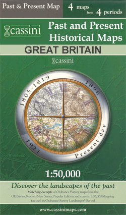
- Richmond and Ealing Past and Present
- London boroughs of Richmond and Ealing in the Cassini Past and Present map series which covers town and cities of England and Wales and offers a unique way of tracing their history and expansion by showing four different periods of their development using Ordnance Survey mapping from the mid-19th century, the late 19th century, the 1920s and... Leer más


Stanfords
United Kingdom
United Kingdom
- London East 1805-1822
- Map No. 177, London East 1805-1822, in the Cassini Historical Series of old Ordnance Survey mapping of England and Wales at 1:50,000 in a format designed to offer a convenient comparison with the present day coverage from the OS, and most locations in three different editions. Old historical maps have been combined so that the sheet lines... Leer más
Stanfords
United Kingdom
United Kingdom
- London East 1897-1902
- Map No. 177, London East 1897-1902, in the Cassini Historical Series of old Ordnance Survey mapping of England and Wales at 1:50,000 in a format designed to offer a convenient comparison with the present day coverage from the OS, and most locations in three different editions. Old historical maps have been combined so that the sheet lines... Leer más

Stanfords
United Kingdom
United Kingdom
- London High 5 Edition Street Plan
- The first water-resistant “Comfort Map“ with direct access to useful additional information from the InternetLondon in a scale of 1:20,000 including tourist destinations (Hampstead Heath, Olympic Park and Greenwich) presented on a practical map; inclusive of the High 5 Edition app technology for calling up additional travel information and many... Leer más

Stanfords
United Kingdom
United Kingdom
- London Greater London Street Finder PAPERBACK
- Detailed paperback street atlas covering the whole of Greater London at three different scales: 1:10,000 scale covers central London; 1:20,000 scale extends from Welwyn Garden City in the north to Gatwick Airport in the south and from Windsor in the west to Gravesend in the east; 1:63,360 scale extends from Highbury in the north to Clapham in... Leer más
Stanfords
United Kingdom
United Kingdom
- London West 1920
- Map No. 176, London West 1920, in the Cassini Historical Series of old Ordnance Survey mapping of England and Wales at 1:50,000 in a format designed to offer a convenient comparison with the present day coverage from the OS, and most locations in three different editions. Old historical maps have been combined so that the sheet lines correspond... Leer más
Stanfords
United Kingdom
United Kingdom
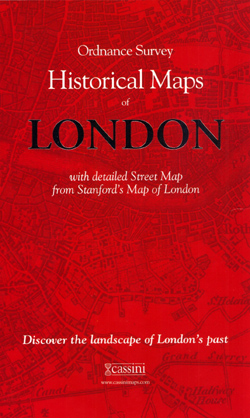
- London Historical Maps Box Set (5-map set)
- London Historical Set of five maps in the Cassini Historical Series reproducing old Ordnance Survey mapping of England and Wales at 1:50,000. The set consists of the four Cassini maps showing the capital between 1805 and 1948, and has as a bonus map a reproduction of Stanfords street plan London at six inches to one mile from 1891.The four... Leer más

Stanfords
United Kingdom
United Kingdom
- Ontario Southwestern: Brantford - London - Kitchener/Waterloo - Bruce Peninsula
- The south-western part of Ontario on a detailed, double-sided road map at 1:250,000 extending from Lake Erie to Lake Huron and the Bruce Peninsula, with five street plans at 1:25,000 covering central London, Windsor, Sarnia, Owen Sound and Stratford.Coverage of the region is divided between the two sides of the map, with a good overlap between... Leer más

Stanfords
United Kingdom
United Kingdom
- Runners London in a Box: Beautiful running routes around London on individual handy, pocket-size cards
- 32 incredible running routes intelligently located all over Greater London. In this unique, boxed collection of folding, pocket-size cards you`ll find a variety of running routes around Greater London. Each card has a different route fully described and illustrated on a large scale, 1:25 000 map and include our carefully planned pitstops along... Leer más
Stanfords
United Kingdom
United Kingdom
- London East 1920-1921
- Map No. 177, London East 1920-1921, in the Cassini Historical Series of old Ordnance Survey mapping of England and Wales at 1:50,000 in a format designed to offer a convenient comparison with the present day coverage from the OS, and most locations in three different editions. Old historical maps have been combined so that the sheet lines... Leer más

Stanfords
United Kingdom
United Kingdom
- London
- London at 1:50,00 with mapping from the Ordnance Survey’s Landranger series published by Cassini to add to their extensive coverage of the city on historical maps reflecting different periods in its development. Unlike the Landranger series which splits the city east/west, the Cassini version is centred on Charing Cross and covers most of the... Leer más

Stanfords
United Kingdom
United Kingdom
- Luxembourg North
- One of two topographic survey maps of Luxembourg at 1:50,000, with contours at 10-metres intervals and additional relief shading. An overprint highlights long-distance footpaths, including the GR5 (E-2), cycle routes, and various places of interest, including campsites. The map covers an area of approximately 53 x 43 km / 33 x 27 miles. Map... Leer más
Stanfords
United Kingdom
United Kingdom
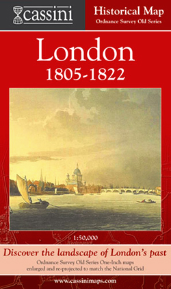
- London 1805-1822
- London in 1805-1822 in the Cassini Historical Series reproducing old Ordnance Survey mapping of England and Wales at 1:50,000. The four London maps cover roughly the area of the present day Greater London rather than following the format of rest of the series which is designed to correspond to the current Landranger maps. Mapping is identical... Leer más
Stanfords
United Kingdom
United Kingdom
- London West 1805-1920 (3-map set)
- Map No. 176, London West 1805-1920 (3-map set), in the Cassini Historical Series of old Ordnance Survey mapping of England and Wales at 1:50,000 in a format designed to offer a convenient comparison with the present day coverage from the OS, and most locations in three different editions. Old historical maps have been combined so that the sheet... Leer más