
Berner Oberland
Descripción
Mapa

Senderos en región
Enlaces
Datos
Informes
Guías y mapas
Hospedaje
Organizaciones
Operadores turísticos
GPS
Otro
Libros

Stanfords
United Kingdom
United Kingdom
- DK Eyewitness Travel Guide Switzerland
- Marvel at the iconic Matterhorn, explore the fascinating art galleries and museums of Basel or stroll around the historic town of Lausanne on Lake Geneva. The DK Eyewitness Guide to Switzerland covers the must-see sights and the hidden backstreets, so you won`t miss a thing.- See Switzerland from a different angle - 14 pages of fresh ideas for... Leer más

The Book Depository
United Kingdom
2018
United Kingdom
2018
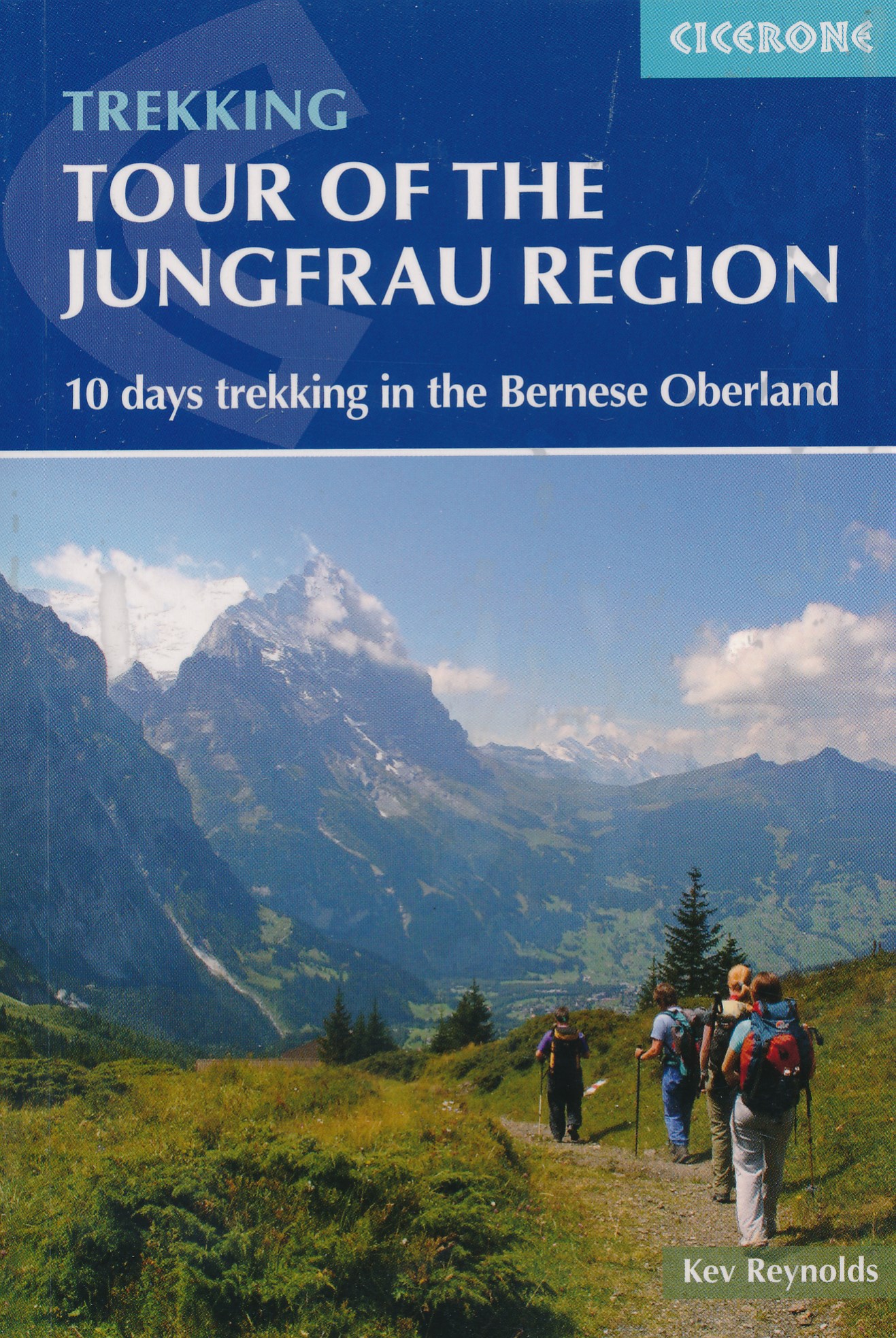
- Tour of the Jungfrau Region
- 10 days trekking in the Bernese Oberland Leer más
- Also available from:
- De Zwerver, Netherlands
De Zwerver
Netherlands
2018
Netherlands
2018
- Wandelgids Tour of the Jungfrau Region - Berner Oberland | Cicerone
- The Tour of the Jungfrau Region is described as a clockwise circuit of 111km beginning at Schynige Platte and ending at Wilderswil. It is broken into 10 stages (with alternatives offered), through the Bernese Oberland under the Mönch, Eiger and Jungfrau. With spectacular mountain views, glaciers, lakes and ridges, it is a classic walk. Leer más

The Book Depository
United Kingdom
United Kingdom
- Best Hiking in Switzerland in the Valais, Bernese Alps, the Engadine and Davos
- Over 100 Hikes in the Spectacular Swiss Alps Leer más
The Book Depository
United Kingdom
United Kingdom
- Bernese Alps Western Touring Route
- Route Guide to the Long Distance Alpine Walk Leer más

- Also available from:
- De Zwerver, Netherlands

The Book Depository
United Kingdom
2023
United Kingdom
2023
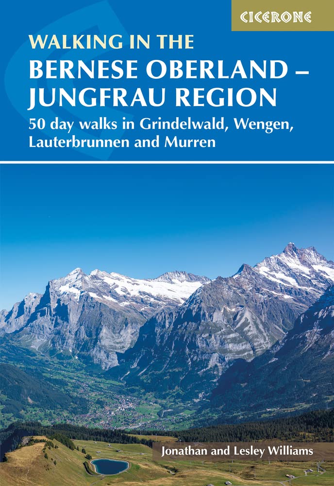
- Walking in the Bernese Oberland - Jungfrau region
- 50 day walks in Grindelwald, Wengen, Lauterbrunnen and Murren Leer más
- Also available from:
- De Zwerver, Netherlands
De Zwerver
Netherlands
2023
Netherlands
2023
- Wandelgids Walking in the Bernese Oberland | Cicerone
- 50 day walks in Grindelwald, Wengen, Lauterbrunnen and Murren Leer más
De Zwerver
Netherlands
2018
Netherlands
2018
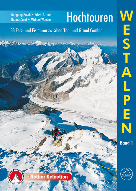
- Klimgids - Klettersteiggids Hochtouren Westalpen | Rother Bergverlag
- 88 Fels- und Eistouren zwischen Tödi und Grand Combin Rother Selection. 4., aktualisierte Auflage. Leer más
Bol.com
Netherlands
2009
Netherlands
2009
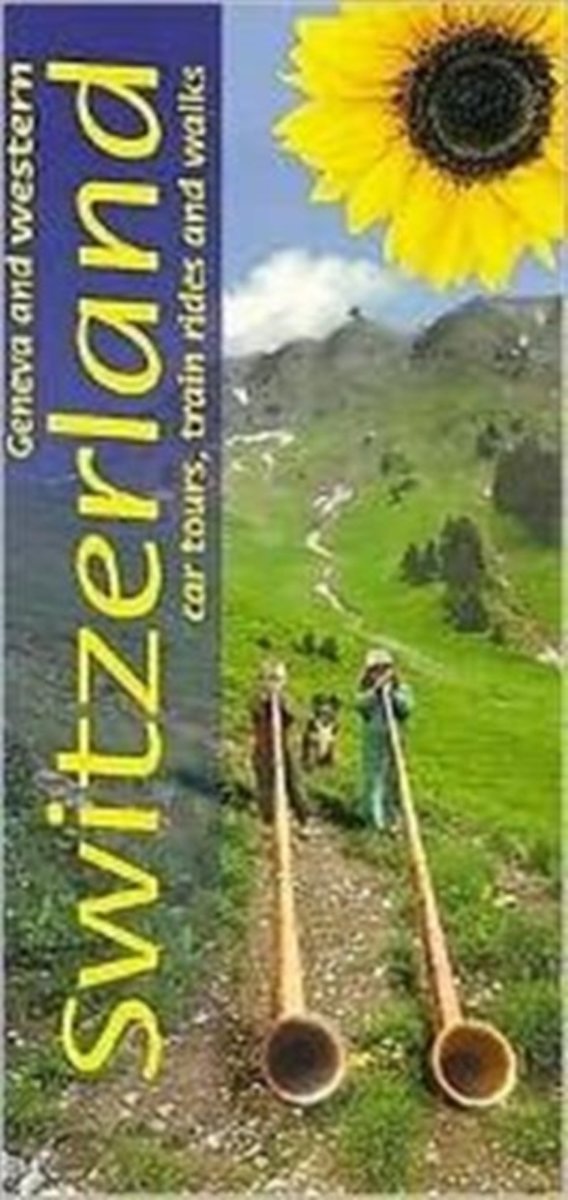
- Geneva & Western Switzerland
- 8 car tours, many suggestions for train, funicular and cable car rides, 150 long and short walks (of which 36 are specially tailored to motorists) Longer than the normal 'Landscapes' guide, this book covers a lot of ground - from the shores of Lake Geneva to the Swiss Jura, the Bernese Oberland and the valleys of the Valais. Although a car is... Leer más
- Also available from:
- Bol.com, Belgium
Bol.com
Belgium
2009
Belgium
2009
- Geneva & Western Switzerland
- 8 car tours, many suggestions for train, funicular and cable car rides, 150 long and short walks (of which 36 are specially tailored to motorists) Longer than the normal 'Landscapes' guide, this book covers a lot of ground - from the shores of Lake Geneva to the Swiss Jura, the Bernese Oberland and the valleys of the Valais. Although a car is... Leer más

The Book Depository
United Kingdom
2010
United Kingdom
2010
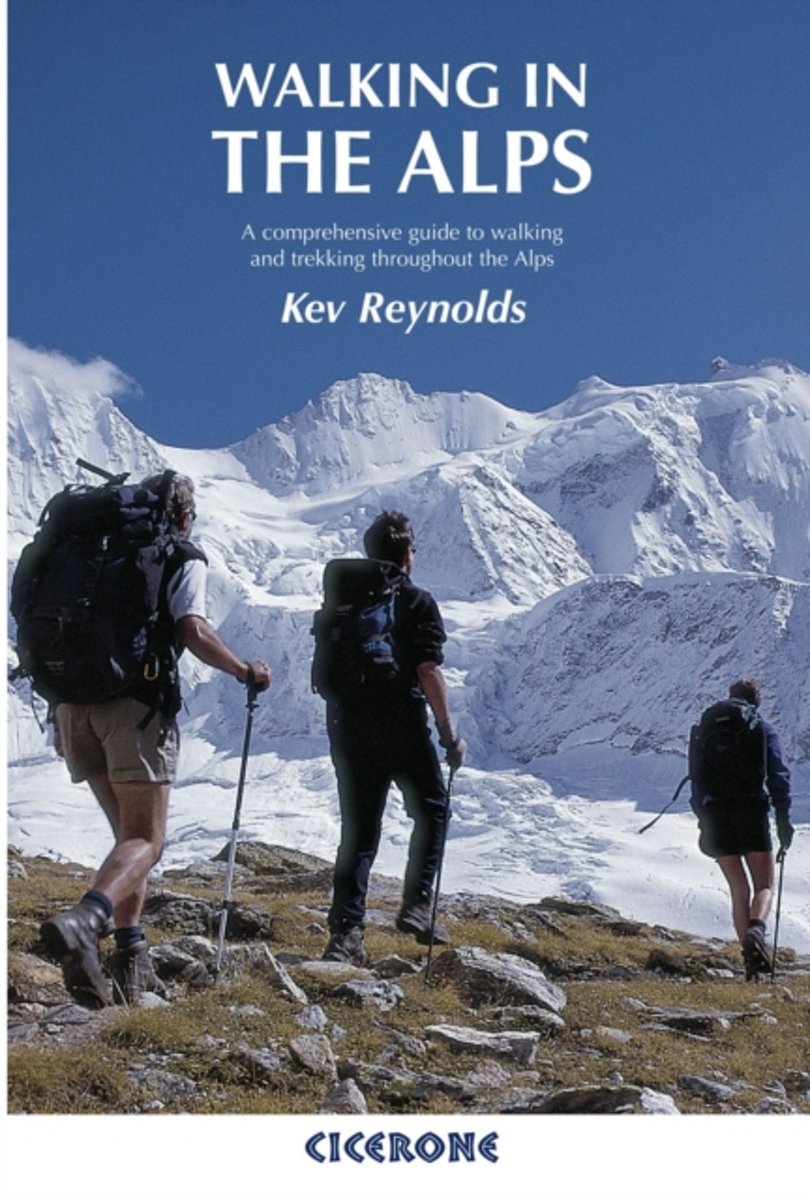
- Walking in the Alps
- A comprehensive guide to walking and trekking throughout the Alps Leer más
- Also available from:
- Bol.com, Netherlands
- Bol.com, Belgium
- De Zwerver, Netherlands
Bol.com
Netherlands
2010
Netherlands
2010
- Walking in the Alps
- The second edition of this classic guidebook by Kev Reynolds on walking and trekking in the Alps. This book is a definitive guide to the many thousands of possible routes, with a geographical span that ranges from the Maritime Alps of southern France to the Julians of Slovenia, from Italy's Gran Paradiso to the little-known Turnitzer Alps of... Leer más
Bol.com
Belgium
2010
Belgium
2010
- Walking in the Alps
- The second edition of this classic guidebook by Kev Reynolds on walking and trekking in the Alps. This book is a definitive guide to the many thousands of possible routes, with a geographical span that ranges from the Maritime Alps of southern France to the Julians of Slovenia, from Italy's Gran Paradiso to the little-known Turnitzer Alps of... Leer más

De Zwerver
Netherlands
2010
Netherlands
2010
- Wandelgids Walking in the Alps | Cicerone
- Second edition of this classic Kev Reynolds guidebook on walking and trekking in the Alps. Suggests many thousands of possible routes, and covers the range from the Maritime Alps of southern France to the Julian Alps of Slovenia. Walks vary from undemanding to long and tough, and everything in between. Leer más

Stanfords
United Kingdom
2015
United Kingdom
2015
- Bernese Oberland - over 100 walking routes in the Bernese Alps
- The Bernese Alps is accomplished walker Kev Reynolds’ Cicerone guide to the best walking routes in the very heart of the Swiss Alps. The guide covers the entirety of the Bernese Alps, including walks near the dramatic peaks of the Eiger, Monch and Jungfrau. Reynolds also covers some of the lesser-known mountains that boast picturesque scenery... Leer más
- Also available from:
- Bol.com, Netherlands
- Bol.com, Belgium
Bol.com
Netherlands
2015
Netherlands
2015
- Walking in the Bernese Oberland
- Over 100 walking routes in the Bernese Alps are described in this guidebook. It is an indispensable companion to the Bernese Oberland region that boasts famous peaks such as the Eiger, Monch and Jungfrau. But there are lesser-known mountains, too, that are just as scenically dramatic, and in their shadow peaceful villages and seemingly... Leer más
Bol.com
Belgium
2015
Belgium
2015
- Walking in the Bernese Oberland
- Over 100 walking routes in the Bernese Alps are described in this guidebook. It is an indispensable companion to the Bernese Oberland region that boasts famous peaks such as the Eiger, Monch and Jungfrau. But there are lesser-known mountains, too, that are just as scenically dramatic, and in their shadow peaceful villages and seemingly... Leer más

Bol.com
Netherlands
Netherlands
- Hiking in Switzerland
- This is the official guidebook to the Swiss section of the Via Alpina (National Route 1), published by the Swiss Hiking Federation. The Via Alpina is a network of five long-distance hiking routes which cross eight Alpine countries from Trieste to Monaco - over 5,000 kilometres of hiking trails in total. On Swiss soil, National Route 1 Via... Leer más
- Also available from:
- Bol.com, Belgium
Bol.com
Belgium
Belgium
- Hiking in Switzerland
- This is the official guidebook to the Swiss section of the Via Alpina (National Route 1), published by the Swiss Hiking Federation. The Via Alpina is a network of five long-distance hiking routes which cross eight Alpine countries from Trieste to Monaco - over 5,000 kilometres of hiking trails in total. On Swiss soil, National Route 1 Via... Leer más

Bol.com
Netherlands
Netherlands
- Wanderland Schweiz 02. Trans Swiss Trail
- Das Wanderland Schweiz besteht aus 6 nationalen Routen und 51 mehrtägigenHighlights. Die Routen basieren auf dem bestehenden Wanderwegnetz und integrierenteilweise bereits bestehende Angebote wie beispielsweise Via Alpina, Jura Höhenweg,Via Jacobi oder Rheintaler Höhenweg.Alle 9 Führer sind mit Farbfotos, Karten und Höhenprofilen farbig reich... Leer más
- Also available from:
- Bol.com, Belgium
Bol.com
Belgium
Belgium
- Wanderland Schweiz 02. Trans Swiss Trail
- Das Wanderland Schweiz besteht aus 6 nationalen Routen und 51 mehrtägigenHighlights. Die Routen basieren auf dem bestehenden Wanderwegnetz und integrierenteilweise bereits bestehende Angebote wie beispielsweise Via Alpina, Jura Höhenweg,Via Jacobi oder Rheintaler Höhenweg.Alle 9 Führer sind mit Farbfotos, Karten und Höhenprofilen farbig reich... Leer más
Mapas

Stanfords
United Kingdom
United Kingdom
- Styrian Winelands - Southwest Styria F&B WK411
- Styrian Winelands area south-eastern Austria presented at 1:50,000 in a series of contoured and GPS compatible outdoor leisure map from Freytag & Berndt with hiking and cycling routes, mountain huts, campsites and youth hostels, local bus stops, plus other tourist information. To see the list of currently available titles in this series please... Leer más

Stanfords
United Kingdom
United Kingdom
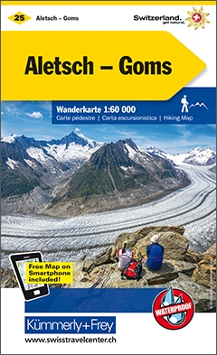
- Goms - Aletsch
- Goms - Aletsch area of the Bernese Oberland at 1:50,000 in a series from Hallwag covering Switzerland’s popular hiking regions on light, waterproof and tear-resistant maps highlighting long-distance paths: the nine national routes plus special regional routes, as well as other local hiking trails.Cartography is similar to that used both in... Leer más

Stanfords
United Kingdom
United Kingdom
- Val Venosta / Vinschgau K+F Outdoor Map 1
- Val Venosta / Vinschgau area in the Dolomites at 1:50,000 in a series of waterproof and tear-resistant, GPS compatible and contoured recreational maps from Kümmerly + Frey with both local and long-distance hiking and cycling trails, ski routes, sites for other outdoor pursuits, accommodation, bus stops, etc. Coverage includes the Ortles/Ortler... Leer más
Stanfords
United Kingdom
United Kingdom
- Haslital: Grindelwald - Engelberg 50K Hallwag Outdoor Map No. 5
- Haslital area, from Grindelwald to Engelberg, at 1:50,000 in a series from Hallwag covering Switzerland’s popular hiking regions on light, waterproof and tear-resistant maps highlighting long-distance paths: the nine national routes plus special regional routes, as well as other local hiking trails.Cartography is similar to that used both in... Leer más
Stanfords
United Kingdom
United Kingdom
- Montreux
- Montreux - Col du Pillon area at 1:50,000 in a series from Hallwag covering Switzerland’s popular hiking regions on light, waterproof and tear-resistant maps highlighting long-distance paths: the nine national routes plus special regional routes, as well as other local hiking trails.Cartography is similar to that used both in Hallwag’s hiking... Leer más
Stanfords
United Kingdom
United Kingdom
- Adelboden - Lenk
- Adelboden - Lenk area of the western Bernese Oberland, from Gstaad to Frutigen and Leukerbad at 1:50,000 in a series from Hallwag covering Switzerland’s popular hiking regions on light, waterproof and tear-resistant maps highlighting long-distance paths: the nine national routes plus special regional routes, as well as other local hiking... Leer más

Stanfords
United Kingdom
United Kingdom
- Lake Maggiore - Lake Orta - Lake Varese K+F Outdoor Map 8
- Lake Maggiore - Lake Orta - Lake Varese area at 1:50,000 in a series of waterproof and tear-resistant, GPS compatible and contoured recreational maps from Kümmerly + Frey with both local and long-distance hiking and cycling trails, ski routes, sites for other outdoor pursuits, accommodation, bus stops, etc. An inset provides a small road map of... Leer más

Stanfords
United Kingdom
United Kingdom
- Gstaad - Adelboden - Lenk Hallwag Mountain Bike Map
- Western Bernese Oberland Mountain Bike Map, covering the Gstaad - Adelboden - Lenk area, at 1:50,000 in a series of waterproof and tear-resistant, contoured mountain biking maps from Hallwag, each highlighting several circuits and providing route profiles, guidance on the difficulty and overall experience, etc. Each map in this series is... Leer más

Stanfords
United Kingdom
United Kingdom
- Lake Como K+F Outdoor Map 9
- Lake Como area at 1:50,000 on a double-sided, waterproof and tear-resistant, GPS compatible and contoured recreational maps from Kümmerly + Frey with both local and long-distance hiking and cycling trails, ski routes, sites for other outdoor pursuits, accommodation, bus stops, etc. Coverage includes the northern part of Lake Lugano and extends... Leer más

Stanfords
United Kingdom
United Kingdom
- Saanenland: Gstaad - Lenk - Adelboden
- 33 specially selected hiking trails in the western part of the Bernese Oberland, around Gstaad, Lenk and Adelboden, presented at 1:50,000 on a waterproof and tear-resistant, contoured and GPS compatible map from the Hallwag/Kümmerly + Frey group, with route profiles, grading for the severity of the terrain and the degree of fitness required,... Leer más

Stanfords
United Kingdom
United Kingdom
- Heidiland - UNESCO Tectonic Arena Sardona 50K K+F Hiking Map No. 33
- Heidiland, including the Swiss Tectonic Arena Sardona – a UNESCO World Heritage Site, at 1:50,000 in Kümmerly + Frey’s hiking series of Switzerland printed on light, waterproof and tear-resistant plastic paper. Coverage includes Walensee, Flumserberg, Pizol, Weisstannental, Sarganserland and Taminatal. Hiking trails highlighted on the map... Leer más
Stanfords
United Kingdom
United Kingdom
- Interlaken - Grindelwald 50K Hallwag Mountainbike Map No.23
- Interlaken - Grindelwald area of the Bernese Oberland on a mountain bike map at 1:50,000 in a series of waterproof and tear-resistant, contoured mountain biking maps from Hallwag, each highlighting several circuits and providing route profiles, guidance on the difficulty and overall experience, etc. Each map in this series is printed on sturdy,... Leer más

Stanfords
United Kingdom
United Kingdom
- Thuner See - Central Switzerland Swisstopo 101
- The Alps of central Switzerland on a Swiss topographic survey map at 1:100,000. Coverage extends south from Luzern to Grindelwald and the Alps of the Bernese Oberland and the Gotthard Pass.Maps in the Swiss topographic survey at 1:100,000 from Swisstopo are highly regarded for their superb use of graphic relief and hill shading, presenting an... Leer más

Stanfords
United Kingdom
United Kingdom
- Val Brembana - Valsassina - Le Grigne: Lecco - Bergamo 50K IGC Map No. 22
- Val Brembana - Valsassina - Le Grigne area including Lecco and Bergamo in a series contoured hiking maps at 1:50,000 with local trails, long-distance footpaths, mountain accommodation, etc. from the Turin based Istituto Geografico Centrale.Maps in this series have contours at 50m intervals, enhanced by shading and graphic relief. An overprint... Leer más

Stanfords
United Kingdom
United Kingdom
- Cinque Terre - Golfo del Tigullio: La Spezia - Sestri Levante - Rapallo - Genoa 50K IGC Map No. 23
- Cinque Terre - Golfo del Tigullio area of the Italian Riviera from genoa to la Spezia including Sestri Levante and Rapallo in a series contoured hiking maps at 1:50,000 with local trails, long-distance footpaths, mountain accommodation, etc. from the Turin based Istituto Geografico Centrale.Maps in this series have contours at 50m intervals,... Leer más