
Aragón
Descripción
Mapa

Senderos en región
- GR1 Sendero Histórico, Senda TransversalGPX
- GR10 Senderos de la MielGPX
- GR11 Sendero PirenaicoGPX
- GR15 Sendero PrepirenaicoGPX
- GR16 Sendero del SerrabloGPX
- GR17 Sendero MarianoGPX
- GR18 Senderos de la RibagorzaGPX
- GR19 Senderos de SobrabeGPX
- GR23 Senderos por la LiteraGPX
- GR24 Senderos de Calatayud, Darroca y GallocantaGPX
- GR260 Vuelta al Moncayo-Calcenada
- GR45 Sendero del SomontanoGPX
- GR65 Camino de SantiagoGPX
- GR8 Puertos de Beceite - JavalambreGPX
- GR90 Tierras del MontcayoGPX
- GR95 Calzada Romana de Zaragoza a FranciaGPX
- GR99 Sendero del EbroGPX
Enlaces
Datos
Informes
Guías y mapas
Hospedaje
Organizaciones
Operadores turísticos
GPS
Otro
Libros

Stanfords
United Kingdom
2021
United Kingdom
2021
- Camino de Santiago: The ancient Way of Saint James pilgrimage route from the French Pyrenees to Santiago de Compostela
- El Camino de Santiago de Compostela, the ancient Christian pilgrimage route has been travelled for over a thousand years to the Cathedral of Santiago de Compostela, where, legend has it, the bones of St James are buried. This guide follows the most popular route, starting at St Jean-Pied-de-Port in south-west France and heading all the way... Leer más

Stanfords
United Kingdom
2020
United Kingdom
2020
- Tour du Larzac, Templier - Hospitalier - Entre causses et vallées GR71C/GR71D
- Tour du Larzac - Templier et Hospitalier, FFRP topoguide Ref. No. 710, covering the 195kms of hiking circuits along the GR71C and GR71D south of Millau in the Causse du Larzac, plus 13 local day walks. Current edition of this title was published in December 2015.ABOUT THE FFRP (Fédération française de la randonnée pédestre) TOPOGUIDES:... Leer más

Stanfords
United Kingdom
2011
United Kingdom
2011
- Le Parc de Millevaches en Limousin à pied FFRP Topo-guide No. PN17
- Le Parc de Millevaches en Limousin à pied, topo-guide Ref. No. PN017, with 18 day walks of varying length and difficulty, plus 270kms of hiking circuits in the department of Creuse. Current edition of this title was published in March 2011.To see the list of other FFRP guides with day walks please click on the series link.ABOUT THE FFRP... Leer más

Stanfords
United Kingdom
United Kingdom
- DK Eyewitness Spain
- Discover Spain - a compelling country filled with must-see sightsWhether you want to explore Granada`s spectacular Alhambra palace, watch swirling flamenco dancers in Seville or walk through lush countryside on the epic Camino de Santiago, your DK Eyewitness travel guide makes sure you experience all that Spain has to offer.From the golden... Leer más

Stanfords
United Kingdom
United Kingdom
- GR3: Les Monts du Forez FFRP Topo-guide No. 334
- Les Monts du Forez, FFRP topoguide Ref. No. 334, covering in all 259kms along the GR3 and its variant, with additional descriptions of 21 day walks in the region. Current edition of this title was published in April 2016.ABOUT THE FFRP (Fédération française de la randonnée pédestre) TOPOGUIDES: published in a handy A5 paperback format, the... Leer más
Stanfords
United Kingdom
2020
United Kingdom
2020
- Les Abers - le Chemin de Phares GR34/GR34F
- Les Abers - le chemin de phares, FFRP topoguide Ref. no. 347, covering the coastal route in north-western Brittany between Morlaix, Brest, and le Fau, plus 4 walks on the Ile d`Ouessant. Current edition of this title was published in September 2017.Between Morlaix and Brest, where the sea has dug deep furrows in the land. More than 20 days of... Leer más

Stanfords
United Kingdom
2018
United Kingdom
2018
- Val d`Azun à pied ST10
- Val d`Azun à pied, FFRP topo-guide Ref. No. ST10, with 18 day walks of varying length and difficulty in the French Pyrenees south-west of Argelès-Gazost, plus a tour which includes part of the GR10 long-distance footpaths. Each walk is presented on a separate colour extract from IGN’s topographic survey of France at 1:25,000 and/or 1:50,000,... Leer más
Stanfords
United Kingdom
2021
United Kingdom
2021
- Tour de l`Oisans et des Ecrins - Parc National des Ecrins GR54/GR541
- Tour de l`Oisans et des Ecrins, FFRP topoguide, Ref. No. 508, covering the 11 to 13 days long tour of the Ecrins massif along the GR54, including the local section of the GR5. Variants along GRs 54A, 54B, 54C, and 541 offer less demanding circuits of two to three days. Current edition of this title was published in April 2014.To see other... Leer más
Stanfords
United Kingdom
2020
United Kingdom
2020
- La Traversee der Alpes La Vanoise - PN de la Vanoise GR5/GR55
- 15 days in altitude from the Tarentaise to Modane, heart of the Maurienne. Description also of Via Alpina.La Vanoise (including Parc National de la Vanoise), FFRP topoguide Ref. no. 530, covering the second section of the GR5 in the French Alps between Landry and Modane, its lower variant on the GR5E along the river Arc, plus the traverse of... Leer más

Stanfords
United Kingdom
2011
United Kingdom
2011
- GRP: Monts et Lacs du Lévézou FFRP Topo-guide No. 1201
- Monts et Lacs du Lévézou, FFRP topo-guide ref. no. 1201, covering two hiking circuits in the Massif Central near Rodez and Millau; in all 214kms of routes. Current edition of this title was published in March 2011.ABOUT THE FFRP (Fédération française de la randonnée pédestre) TOPOGUIDES: published in a handy A5 paperback format, the guides are... Leer más

Stanfords
United Kingdom
2018
United Kingdom
2018
- Pyrénées Ariégeoises - La traversée des Pyrénées et tours du Val du Garbet et du Biros GR10
- Pyrénées Ariégeoises, FFRP topoguide, Ref. No. 1090, covering the third section of the GR10 along the Pyrenees from the Atlantic to the Mediterranean – a 335-km long walk from Bagnères-de-Luchon to Mérens-les-Vals. Given the mountainous terrain, the guide also provides a detailed route profile for this part of the GR10, annotated with timings... Leer más

Stanfords
United Kingdom
2013
United Kingdom
2013
- GR6/61/62/63/66/67: Grande Traversee du Gard, Mont Aigoual - Avignon FFRP Topo-guide No. 603
- Grande Traversée du Gard: Mont Aigoual - Avignon, FFRP topoguide, Ref. No. 603, covering ten GR routes in the Cevennes and in the department of Gard: GR6 from Beaucaire to Meyrueis (164.5km), GR63 from Avignon to Col de la Lusette (142.5km), GR67 – a 120.5km circuit from Anduze, GR66 – an 81km tour of Mont Aigoual starting at L’Espérou, plus... Leer más

Stanfords
United Kingdom
2014
United Kingdom
2014
- GR430: Chemin de St-Regis - Entre Velay et Vivarais FFRP Topo-guide No. 430
- Chemin de St-Regis - Entre Velay et Vivarais, FFRP topoguide Ref. no. 430, covering a 210km circuit eastwards from Le Puy-en-Velay in the mountains of the Ardèche region. Current edition of this title was published in October 2014.ABOUT THE FFRP (Fédération française de la randonnée pédestre) TOPOGUIDES: published in a handy A5 paperback... Leer más
Stanfords
United Kingdom
2020
United Kingdom
2020
- Le Chemin de Saint-Guilhem-le-Desert - Lozere - Aveyron - Gard - Herault
- Le chemin de Saint-Guilhem-le Désert, FFRP topoguide Ref. No. 4834, covering the 340kms of hiking routes between Aumont-Aubrac in the Massif Central, across the Cevennes, to Saint-Guilhem-le-Désert near Montpellier. Current edition of this title was published in July 2018ABOUT THE FFRP (Fédération française de la randonnée pédestre) TOPOGUIDES:... Leer más

Stanfords
United Kingdom
2019
United Kingdom
2019
- Cote d`Emeraude - Les Chemins du Mont-Saint-Michel GR34/GR37
- Côte d`Emeraude: Les Chemins du Mont-St-Michel, FFRP topoguide Ref. no. 345, covering in all 636km of GR routes in western Brittany: the coastal path between Mont-St-Michel, St-Malo and St-Brieuc, plus circuits linking Rennes with the coast. Current edition of this title was published in March 2019 ABOUT THE FFRP (Fédération française de la... Leer más
Mapas

Stanfords
United Kingdom
United Kingdom
- Ordesa - Monte Perdido National Park Editorial Alpina 2-Map Set
- Ordesa and Monte Perdido National Park at 1:25,000 in a set of two GPS compatible recreational maps in an extensive and very popular series from Editorial Alpina, providing more detailed coverage of this popular hiking area.Contours are at 10m intervals, with relief shading and vegetation colouring. An overprint highlights waymarked PR hiking... Leer más

Stanfords
United Kingdom
United Kingdom
- La Senda de Camille Editorial Alpina
- La Senda de Camille, the Pyrenean Bear Trail, a 104-km circuit in the central Pyrenees, on a contoured GPS compatible map at 1:25,000 from Editorial Alpina, plus a booklet providing information on mountain refuges. The route, which crosses over from the Spanish side to the Parc National des Pyrénées in France and incorporates part of the... Leer más

Stanfords
United Kingdom
United Kingdom
- GR 11: La Senda
- GR11 long-distance footpaths along the Spanish side of the Pyrenees in a French language guide from Rando Editions, with extracts from the publisher’s topographic series at 1:50,000 highlighting the route and mountain refuges.The guide divides the route into 40 sections and covers it from the Mediterranean, starting at Cap de Creus on the Costa... Leer más
Stanfords
United Kingdom
United Kingdom
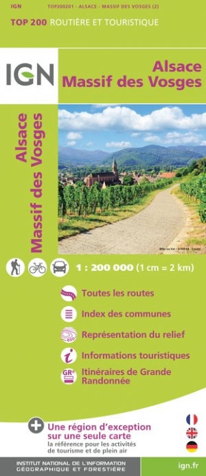
- Massif des Vosges - Plaine d`Alsace IGN Top200 201
- Pyrénées Ouest map from the IGN at 1:200,000, with excellent presentation of the terrain through contours and vivid relief shading, plenty of names of topographic features, long-distance GR hiking routes, places of interest, etc. The map is designed to provide convenient coverage of the western and central part of the Pyrenees, extending across... Leer más
Stanfords
United Kingdom
United Kingdom
- Molina de Aragon CNIG Topo 489
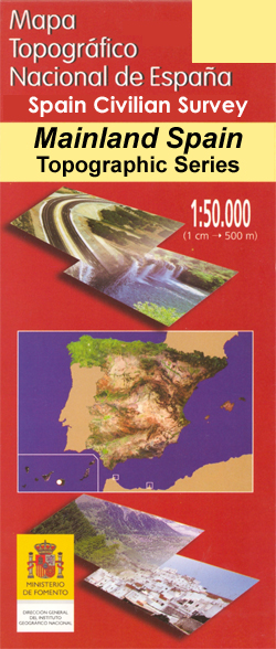
- Topographic coverage of mainland Spain at 1:50,000 in the MTN50 (Mapa Topográfico Nacional) series from the Centro Nacional de Información Geografica, the country’s civilian survey organization. The maps have contours at 20m intervals, enhanced by relief shading, plus colouring and/or graphics to show different types of terrain, vegetation or... Leer más

Stanfords
United Kingdom
United Kingdom
- Pays Basque West Rando Editions 1 SUPERCEDED
- The westernmost section of the French Pyrenees between the Atlantic coast and St-Jean-Pied-de-Port on a contoured and GPS compatible map at 1:50,000 from Rando Editions with topographic base provided by the IGN, highlighting local and long-distance hiking trails, cycle and mountain bike routes, etc. Coverage along the Atlantic coast starts at... Leer más

Stanfords
United Kingdom
United Kingdom
- Terres de l`Ebre
- Terres de l`Ebre map at 1:100,000 in the topographic survey of Catalonia published by the Institut Cartogràfic de Catalunya, with very detailed coverage of a large area and an excellent representation of the region’s topography. Maps in this series have relief presented by contours at 40m intervals, enhanced by additional hill-shading and spot... Leer más
Stanfords
United Kingdom
2016
United Kingdom
2016
- Sur les Traces des Cathares GR107 FR et ES Plus de 10 Jours de Randonnee: FFR.1097: 2016
- Sur les traces des Cathares, Le Chemin des Bonshommes GR 10 Topo Guide FFRP ref 1097 Hiking guide for the French Pyrenees with description of a multi-day hike of 220 km for 10 days hiking through the Cathar country from Foix, Ariege along Andorra to Berga ( Pyrenees France and Spain).French-speaking hiking guide. Excellent description with... Leer más

Stanfords
United Kingdom
United Kingdom
- Pirineu Oriental - Girona - Costa Brava
- Pirineu Oriental - Girona - Costa Brava map, covering the eastern part of the Catalan Pyrenees and the coast southwards to Pineda de Mar at 1:100,000 in the topographic survey of Catalonia published by the Institut Cartogràfic de Catalunya, with very detailed coverage of a large area and an excellent representation of the region’s topography.... Leer más
Stanfords
United Kingdom
United Kingdom
- Pla de Lleida
- Pla de Lleida map at 1:100,000 in the topographic survey of Catalonia published by the Institut Cartogràfic de Catalunya, with very detailed coverage of a large area and an excellent representation of the region’s topography. Maps in this series have relief presented by contours at 40m intervals, enhanced by additional hill-shading and spot... Leer más
Stanfords
United Kingdom
United Kingdom
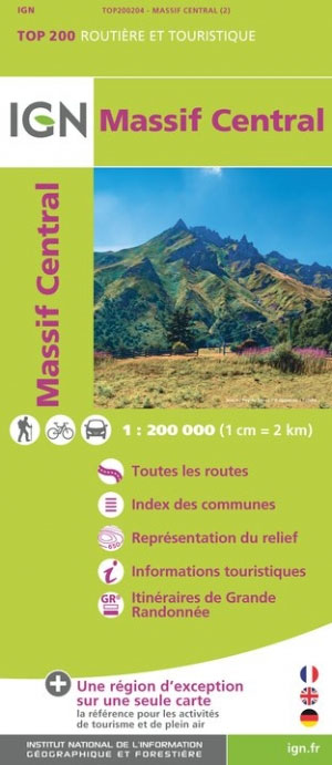
- Massif Central IGN Top200 204
- Pyrénées Ouest map from the IGN at 1:200,000, with excellent presentation of the terrain through contours and vivid relief shading, plenty of names of topographic features, long-distance GR hiking routes, places of interest, etc. The map is designed to provide convenient coverage of the western and central part of the Pyrenees, extending across... Leer más
Stanfords
United Kingdom
2019
United Kingdom
2019
- Tours et Traversées du Vercors - du Diois et les Baronnies GR9/GR91
- Tours et Traversées dans Vercors, le Diois et les Baronnies, FFRP topo-guide Ref. No. 904, covering in all over 1000 km of routes and circuits along the GR9, GR91, GR93, GR95, GR429 and GRs de Pays between Grenoble, Die and Brantes in Provence north of Mt Ventoux. Topographic mapping from the IGN is accompanied by detailed route descriptions,... Leer más
Stanfords
United Kingdom
United Kingdom
- Pirineu Occidental
- Pirineu Occidental, the western part of the Catalan Pyrenees, at 1:100,000 in the topographic survey of Catalonia published by the Institut Cartogràfic de Catalunya, with very detailed coverage of a large area and an excellent representation of the region’s topography.Maps in this series have relief presented by contours at 40m intervals,... Leer más

Stanfords
United Kingdom
2010
United Kingdom
2010
- Camino de Santiago 50K CNIG Topo 11-Map Box Set
- The whole of Way of St James to Santiago de Compostela in a set of 11 maps: 10 double-sided topographic maps at 1:50,000 plus an overview map of northern Spain, published by the Spanish civilian survey organization.Each 1:50,000 map is double-sided and has four 57 x 35cm panels with full topographic mapping of the area through which the route... Leer más

Stanfords
United Kingdom
2017
United Kingdom
2017
- Le Chemin du Piemont Pyreneen - vers Saint-Jacques-de-Compostell
- Le Chemin du Piémont Pyrénéen, FFRP topoguide, Ref. No. 780, covering the GR78 - the Way of St. James along the northern side of the Pyrenees from Carcassonne to Roncesvalles on the Spanish side, with an alternative variant to cross the mountains along the Col du Somport. Current edition of this title was published in May 2017.The route, the... Leer más