
Garda
Descripción
Mapa

Senderos en región
Enlaces
Datos
Informes
Guías y mapas
Hospedaje
Organizaciones
Operadores turísticos
GPS
Otro
Libros

Stanfords
United Kingdom
2015
United Kingdom
2015
- Italian Lakes Walking: Garda, Maggiore, Como and Iseo
- This guidebook describes 50 walks around Lakes Como, Iseo, Garda and Maggiore in Northern Italy. The picturesque routes are accessible by public transport from popular centres including Bellagio, Riva, Stresa and Cannero, and range from 2 to 14km in length. There are gentle lakeside strolls, and numerous ridge routes and traverses as well as... Leer más

Stanfords
United Kingdom
United Kingdom
- Insight Guides Explore Italian Lakes (Travel Guide with Free eBook)
- Discover the best of the Italian Lakes with this unique travel guide, packed full of insider information and stunning images. From making sure you don`t miss out on must-see, top attractions like Lake Garda, Lake Como and Lake Maggiore, to discovering cultural gems, including the imposing Rocca Borromeo in Angera, spectacular food and wine at... Leer más

Stanfords
United Kingdom
United Kingdom
- DK Eyewitness Venice and the Veneto
- Welcome to this enchanting corner of ItalyWhether you want to wander around a magical maze of canals, sample delicious cuisine, ramble through majestic mountains or relive fascinating history, your DK Eyewitness travel guide makes sure you experience all that Venice and the Veneto have to offer.The jewel of the Veneto, Venice is a dreamlike... Leer más

Stanfords
United Kingdom
United Kingdom
- Dolomiti di Braies - Pragser Dolomiten Kompass 145
- Map No. 145, Dolomiti di Braies - Pragser Dolomiten at 1:25,000 printed on sturdy waterproof and tear-resistant plastic paper. The map is part of Kompass series providing detailed coverage of the Dolomites and Lake Garda area and supplementing their main series of walking maps of Italy at 1:50,000. Maps in this series have a more detailed base... Leer más

Stanfords
United Kingdom
United Kingdom
- Naturno / Naturns - Laces / Latsch - Val Senales / Schnalstal Kompass 051
- Map No. 051, Naturno/Naturns - Laces/Latsch, from Kompass, printed on waterproof and tear-resistant synthetic paper in a series providing detailed coverage of the Dolomites and Lake Garda area and supplementing their main series of walking maps of Italy at 1:50,000. Maps in this series have a more detailed base and smaller contour interval than... Leer más

Stanfords
United Kingdom
2019
United Kingdom
2019
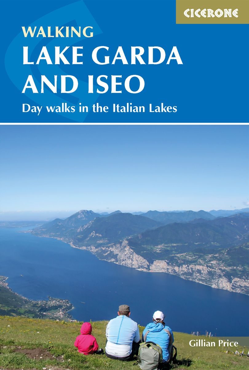
- Walking Lake Garda & Iseo
- This guidebook describes 20 walks around Lakes Garda and Iseo in Northern Italy. The routes range from 4 to 13km in length and are graded 1 to 3. There is something for everyone, from easy leisurely strolls for first-time walkers to strenuous climbs up panoramic peaks.The clear maps, inspirational photographs and information about accommodation... Leer más
- Also available from:
- The Book Depository, United Kingdom
- De Zwerver, Netherlands

The Book Depository
United Kingdom
2019
United Kingdom
2019
- Walking Lake Garda and Iseo
- Day walks in the Italian Lakes Leer más
De Zwerver
Netherlands
2019
Netherlands
2019
- Wandelgids Walking Lake Garda and Iseo | Cicerone
- Guidebook to 20 day walks around the majestic Italian lakes of Garda and Iseo. The routes, which range from leisurely strolls to more strenuous routes up panoramic peaks, offer something to suit all walkers. Invaluable practical information about public transport, accommodation and walking kit is included, together with a handy Italian glossary. Leer más

The Book Depository
United Kingdom
United Kingdom
- Alla scoperta delle Prealpi Venete
- 30 escursioni a piedi dal lago di Garda alla diga del Vajont Leer más

Bol.com
Netherlands
1995
Netherlands
1995
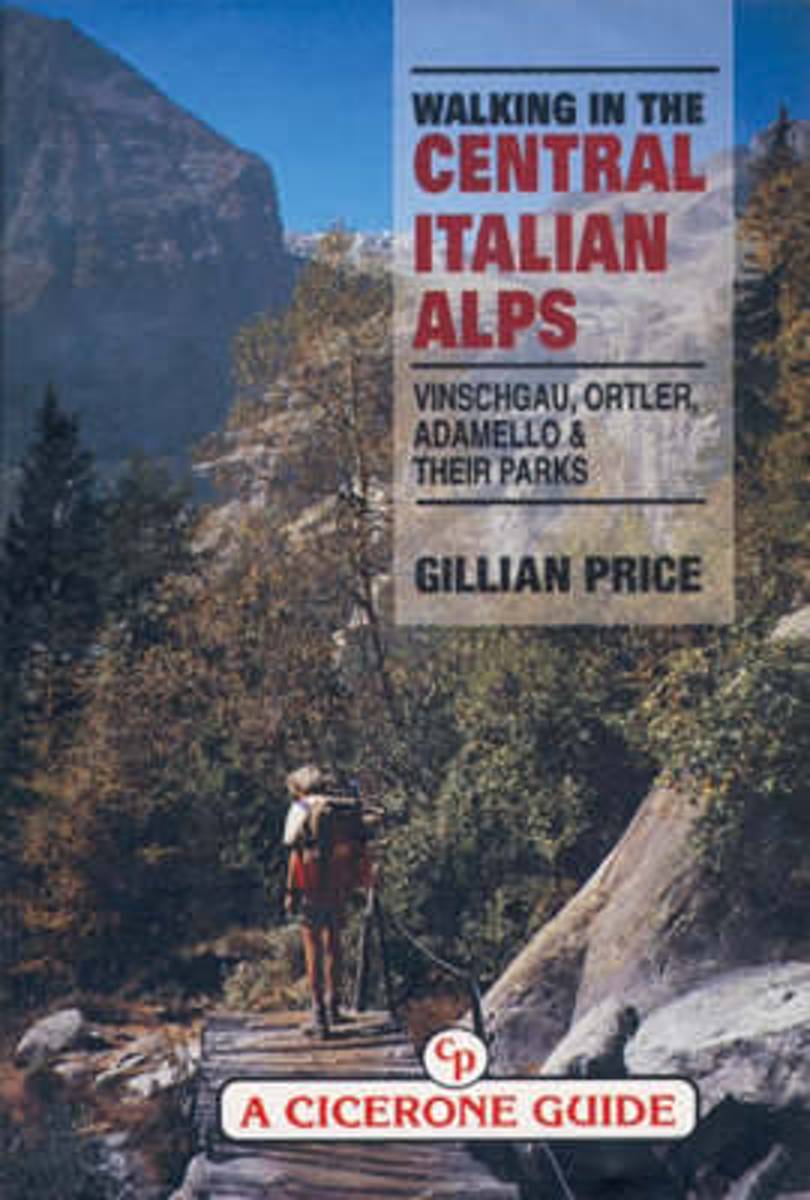
- Walking in the Central Italian Alps
- Guidebook by local expert Gillian Price to walking and trekking in the Central Italian Alps, Italy, Europe presenting a kaleidoscope of walking routes through Italy's largest National Park as well as several Nature Parks. Unusual wildlife, brilliant flora at incredible altitudes, desolate glacial valleys and picturesque legends about the icy... Leer más
- Also available from:
- Bol.com, Belgium
Bol.com
Belgium
1995
Belgium
1995
- Walking in the Central Italian Alps
- Guidebook by local expert Gillian Price to walking and trekking in the Central Italian Alps, Italy, Europe presenting a kaleidoscope of walking routes through Italy's largest National Park as well as several Nature Parks. Unusual wildlife, brilliant flora at incredible altitudes, desolate glacial valleys and picturesque legends about the icy... Leer más

De Zwerver
Netherlands
2024
Netherlands
2024
- Klimgids - Klettersteiggids Alpine Klettersteige Ostalpen | Rother Bergverlag
- 70 spannende Touren zwischen Wien, Bodensee und Gardasee Rother Selection. 1. Auflage. Leer más
Bol.com
Netherlands
Netherlands
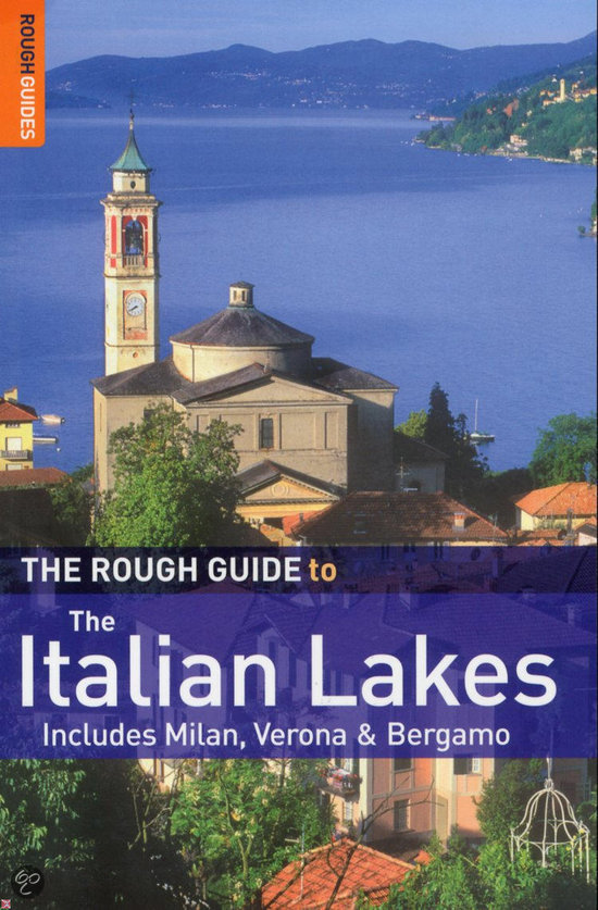
- The Rough Guide to the Italian Lakes
- The Rough Guide to The Italian Lakes is the definitive guide to this region of legendary natural beauty. A 16-page full colour section introduces the highlights of the lakes with inspiring accounts of all the sights, from the Duomo in Milan to the villas and gardens of Lake Garda. In addition there are two full-colour 4-page inserts on... Leer más
- Also available from:
- Bol.com, Belgium
Bol.com
Belgium
Belgium
- The Rough Guide to the Italian Lakes
- The Rough Guide to The Italian Lakes is the definitive guide to this region of legendary natural beauty. A 16-page full colour section introduces the highlights of the lakes with inspiring accounts of all the sights, from the Duomo in Milan to the villas and gardens of Lake Garda. In addition there are two full-colour 4-page inserts on... Leer más

The Book Depository
United Kingdom
2015
United Kingdom
2015
- Via Ferratas of the Italian Dolomites: Vol 2
- Southern Dolomites, Brenta and Lake Garda Leer más
- Also available from:
- Bol.com, Netherlands
- Bol.com, Belgium
- De Zwerver, Netherlands
Bol.com
Netherlands
2015
Netherlands
2015
- Via Ferratas of the Italian Dolomites
- This guidebook, Via Ferratas of the Italian Dolomites Volume 2, is the second in a series of two published by Cicerone Press, which now fully replaces the previous Cicerone guidebook, Scrambles in the Dolomites, adding many new routes through the southern, Brenta and Lake Garda areas.Volume two documents southern Dolomites Via Ferrata routes in... Leer más
Bol.com
Belgium
2015
Belgium
2015
- Via Ferratas of the Italian Dolomites
- This guidebook, Via Ferratas of the Italian Dolomites Volume 2, is the second in a series of two published by Cicerone Press, which now fully replaces the previous Cicerone guidebook, Scrambles in the Dolomites, adding many new routes through the southern, Brenta and Lake Garda areas.Volume two documents southern Dolomites Via Ferrata routes in... Leer más
De Zwerver
Netherlands
2019
Netherlands
2019
- Klimgids - Klettersteiggids - Wandelgids Via Ferratas of the Italian Dolomites: Vol 2 | Cicerone
- Guidebook to 77 via ferrata routes in the Italian Dolomites in the southern regions, Brenta and Garda. Part of a two-volume set of guides to the Dolomite via ferratas. There are graded routes covering 14 mountain groups including the Civetta, around Trento and the Adige valley, with guidance on the best base for each of the via ferrata routes. Leer más
De Zwerver
Netherlands
2017
Netherlands
2017
- Wandelgids Gardameer | Uitgeverij Elmar
- de mooiste dal- en bergwandelingen Leer más
Mapas

Stanfords
United Kingdom
United Kingdom
- Monti de Valle Aurina / Ahrntaler Berge Kompass 082
- Map No. 082, Monti de Valle Aurina/Ahrntaler Berge , from Kompass in a series providing detailed coverage of the Dolomites and Lake Garda area and supplementing their main series of walking maps of Italy at 1:50,000. Maps in this series have a more detailed base and smaller contour interval than coverage at 1:50,000.*Cartography:* maps at... Leer más

Stanfords
United Kingdom
United Kingdom
- Lake Garda North Supertrail Map
- The new Supertrail Maps show the best singletrails in Europe’s hottest mountain bike spots. These unique topographic maps make the knowledge of locals available to other mountain bikers. Consistent difficulty rating and useful additional information prevent the user from critical situations on the trails. The best singletrails in the best... Leer más
Stanfords
United Kingdom
United Kingdom
- Monti Sarentino / Sarntal Alps Kompass 056
- Map No. 056, Val Sarentino/Sarntal, from Kompass in a series providing detailed coverage of the Dolomites and Lake Garda area and supplementing their main series of walking maps of Italy at 1:50,000. Maps in this series have a more detailed base and smaller contour interval than coverage at 1:50,000.*Cartography:* maps at 1:25,000 have contours... Leer más
Stanfords
United Kingdom
United Kingdom
- Texelgruppe NP - Merano High Route Kompass 043
- Map No. 043, Texelgruppe NP - Merano High Route, from Kompass, printed on strudy waterproof and tear-resistant plastic paper in a series providing detailed coverage of the Dolomites and Lake Garda area and supplementing their main series of walking maps of Italy at 1:50,000. Maps in this series have a more detailed base and smaller contour... Leer más

Stanfords
United Kingdom
United Kingdom
- Monti Lessini - Gruppo della Carega - Recoaro Terme Kompass 100
- Map No. 100, Monti Lessini - Gruppo della Carega - Recoaro Terme, from Kompass in a series of walking maps of selected areas of Italy at 1:50,000, with hiking routes on a topographic base, various types of accommodation, recreational facilities, places of interest, etc. Kompass are Europe’s largest publishers of walking maps, with extensive... Leer más

Stanfords
United Kingdom
United Kingdom
- Lake Garda South Supertrail Map
- The new Supertrail Maps show the best singletrails in Europe’s hottest mountain bike spots. These unique topographic maps make the knowledge of locals available to other mountain bikers. Consistent difficulty rating and useful additional information prevent the user from critical situations on the trails. The best singletrails in the best... Leer más
Stanfords
United Kingdom
United Kingdom
- Alta Val Venosta / Obervinschgau Kompass 041
- Map No. 041, Alta Val Venosta/Obervinschgau, from Kompass, printed on waterproof and tear-resistant synthetic paperin a series providing detailed coverage of the Dolomites and Lake Garda area and supplementing their main series of walking maps of Italy at 1:50,000. Maps in this series have a more detailed base and smaller contour interval than... Leer más

Stanfords
United Kingdom
United Kingdom
- Veneto Bikeline Cycle Atlas: Lake Garda to the Adriatic Coast (1298km)
- Veneto Cycle Atlas with 20 tours in the region between Lake Garda and the Adriatic Coast, a total of nearly 1300 kms of cycle trails taking in some of Italy’s most interesting towns: Verona, Venice, Padua, Vicenza, etc. The atlas is presented by the Verlag Esterbauer as a guide with maps at 1:75,000 showing the routes and their variants.... Leer más
Stanfords
United Kingdom
United Kingdom
- Bressanone / Brixen and Environs Kompass 050
- Map No. 050, Bressanone/Brixen and Environs - with a panorama map on the reverse, from Kompass in a series providing detailed coverage of the Dolomites and Lake Garda area and supplementing their main series of walking maps of Italy at 1:50,000. Maps in this series have a more detailed base and smaller contour interval than coverage at... Leer más

Stanfords
United Kingdom
United Kingdom
- Lecco - Valle Brembane - Alpi Orobie Kompass 105
- Map No. 105, Lecco - Valle Brembane, from Kompass, now published on sturdy, waterproof and tear-resistant plastic paper, in a series providing detailed coverage of the Dolomites and Lake Garda area and supplementing their main series of walking maps of Italy at 1:50,000. Maps in this series have a more detailed base and smaller contour interval... Leer más

Stanfords
United Kingdom
United Kingdom
- Lake Garda South - Bardolino - Lazise - Desenzano del Garda Kompass 695
- The area around the southern part of Lake Garda on waterproof and tear-resistant, contoured and GPS compatible map at 1:25,000 from Kompass. Contour interval is 20m, with extensive overprint for hiking trails, cycle routes including a selection of mountain bike routes), ski routes, accommodation and recreational facilities, etc.OTHER KOMPASS... Leer más

Stanfords
United Kingdom
United Kingdom
- Alto Garda and Ledro - Riva del Garda - Malcesine - Torbole - Limone sul Garda Kompass 690
- The area around the northern part of Lake Garda, including the Ledro Valley and Lago di Ledro, on a contoured and GPS compatible map at 1:25,000 from Kompass. Contour interval is 25m, with extensive overprint for hiking trails, cycle routes (including a selection of mountain bike trails), accommodation and recreational facilities, etc.OTHER... Leer más

Stanfords
United Kingdom
United Kingdom
- Merano Kompass 053
- Map No. 053, Merano - with a panorama map on the reverse, from Kompass printed on waterproof and tear-resistant synthetic paper in a series providing detailed coverage of the Dolomites and Lake Garda area and supplementing their main series of walking maps of Italy at 1:50,000. Maps in this series have a more detailed base and smaller contour... Leer más
Stanfords
United Kingdom
United Kingdom
- Val Badia / Gedertal Kompass 51
- Map No. 624, Alta Badia/Hochabtai, from Kompass in a series providing detailed coverage of the Dolomites and Lake Garda area and supplementing their main series of walking maps of Italy at 1:50,000. Maps in this series have a more detailed base and smaller contour interval than coverage at 1:50,000.*Cartography:* maps at 1:25,000 have contours... Leer más

Stanfords
United Kingdom
United Kingdom
- Valsugana - Trento - Piné - Levico - Lavarone Kompass 75
- Valsugana - Trento - Piné - Levico – Lavarone area of southern Dolomites on a GPS compatible hiking and recreational map at 1:50,000 from Kompass, printed on durable, waterproof and tear-resistant synthetic paper. On the reverse is a panorama of the Trentino region, extending from Monte Baldo and the northern part of Lake Garda northwards to... Leer más