
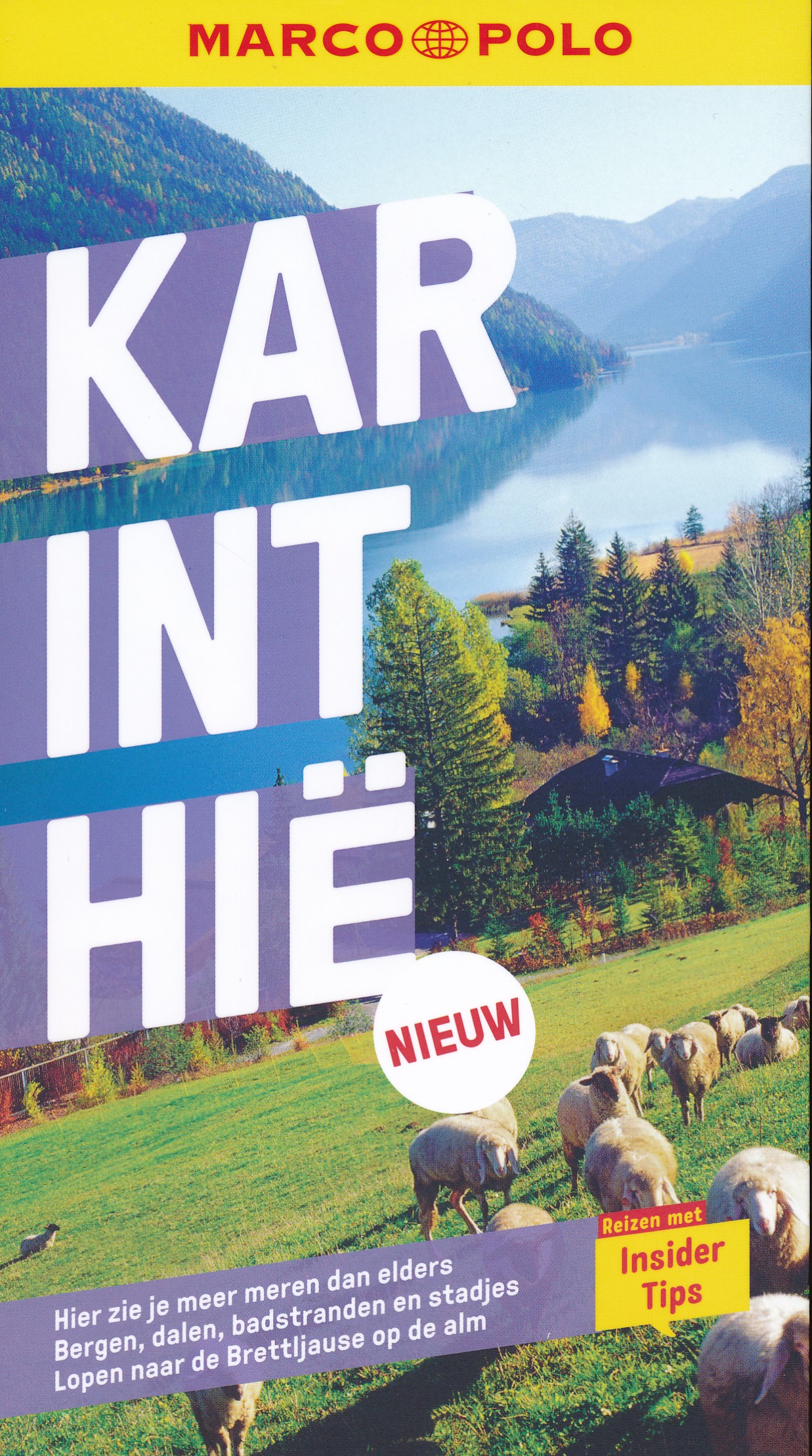
Kärnten
Descripción
Southernmost Bundesland of Austria, bordering Italy.
Senderos en estado
Enlaces
Datos
Informes
Guías y mapas
Hospedaje
Organizaciones
Operadores turísticos
GPS
Otro
Libros

Stanfords
United Kingdom
United Kingdom
- Worthersee - Karawanken West Kompass 61
- Wörther See - Karawanken West (No. 61), a detailed, GPS compatible map at 1:50,000 from Kompass with local and long-distance footpaths, cycling routes, accommodation, etc, printed on durable, waterproof and tear-resistant synthetic paper. This title has on the reverse an additional panorama map of the region.KOMPASS HIKING & RECREATIONAL... Leer más

Stanfords
United Kingdom
United Kingdom
- Millstätter See - Nockgebiet Kompass 63
- Millstätter See - Nockgebiet (No. 63), a detailed, GPS compatible map at 1:50,000 from Kompass with local and long-distance footpaths, cycling routes, accommodation, etc, printed on durable, waterproof and tear-resistant synthetic paper. This title has on the reverse an additional panorama map of the region.KOMPASS HIKING & RECREATIONAL... Leer más

The Book Depository
United Kingdom
2018
United Kingdom
2018
- The Karnischer Hohenweg
- A 1-2 week trek on the Carnic Peace Trail: Austria and Italy Leer más
- Also available from:
- De Zwerver, Netherlands

De Zwerver
Netherlands
2018
Netherlands
2018
- Wandelgids Trekking the Karnischer Höhenweg | Cicerone
- English-language guidebook to the Karnischer Höhenweg, a 206km waymarked hut-to-hut trek along the border between Italy and Austria. Also known as the Carnic Peace Trail, it runs west to east along the Ridge of the Carnic Alps, the site of the WW1 front line. With information on planning your trip, accommodation and the history of the area. Leer más
De Zwerver
Netherlands
2020
Netherlands
2020
- Wandelgids Kärnten - Karinthië Alm- und Hüttenwanderungen | Rother Bergverlag
- 51 Touren zwischen Großglockner und Koralm. Mit GPS-Tracks. Leer más


Bol.com
Netherlands
Netherlands
- Hiking in Switzerland
- This is the official guidebook to the Swiss section of the Via Alpina (National Route 1), published by the Swiss Hiking Federation. The Via Alpina is a network of five long-distance hiking routes which cross eight Alpine countries from Trieste to Monaco - over 5,000 kilometres of hiking trails in total. On Swiss soil, National Route 1 Via... Leer más
- Also available from:
- Bol.com, Belgium
Bol.com
Belgium
Belgium
- Hiking in Switzerland
- This is the official guidebook to the Swiss section of the Via Alpina (National Route 1), published by the Swiss Hiking Federation. The Via Alpina is a network of five long-distance hiking routes which cross eight Alpine countries from Trieste to Monaco - over 5,000 kilometres of hiking trails in total. On Swiss soil, National Route 1 Via... Leer más

Bol.com
Netherlands
Netherlands
- Un Jubilado En Los Alpes
- Se aproximaba el verano y era necesario decidirse. Entre unos pocos proyectos previstos hasta esos dias, que habian ido surgiendo en mi imaginacion durante el invierno, se fueron concretando a mitad de la primavera la posibilidad de caminar por el Himalaya, en Cachemira, recorrer algunos valles del Caucaso al norte de Georgia o atravesar los... Leer más
- Also available from:
- Bol.com, Belgium
Bol.com
Belgium
Belgium
- Un Jubilado En Los Alpes
- Se aproximaba el verano y era necesario decidirse. Entre unos pocos proyectos previstos hasta esos dias, que habian ido surgiendo en mi imaginacion durante el invierno, se fueron concretando a mitad de la primavera la posibilidad de caminar por el Himalaya, en Cachemira, recorrer algunos valles del Caucaso al norte de Georgia o atravesar los... Leer más

De Zwerver
Netherlands
2022
Netherlands
2022
- Wandelgids Karnischer Höhenweg | Rother Bergverlag
- Goede duidelijke beschrijving van deze meerdaagse wandeltocht. Voldoende info, zelfs kaartjes zijn behoorlijk goed en voldoende! Unter den Mehrtagestouren von Hütte zu Hütte nimmt der Karnische Höhenweg eine Sonderstellung ein: Er »verdankt« seine Entstehung der österreichisch-italienischen Frontlinie im Ersten Weltkrieg, die sich entlang der... Leer más

Bol.com
Netherlands
Netherlands
- Over the Top & Back Again
- Book of the Year Bronze Award 2010 (travel essays category), ForeWord Magazine After hiking some of the world's great trails, Brandon Wilson was excited to hear about the Via Alpina, paths running across eight countries on the backbone of the Alps. Besides promising immersion into Alpine life and wilderness, it was the ultimate adventure. It... Leer más
- Also available from:
- Bol.com, Belgium
Bol.com
Belgium
Belgium
- Over the Top & Back Again
- Book of the Year Bronze Award 2010 (travel essays category), ForeWord Magazine After hiking some of the world's great trails, Brandon Wilson was excited to hear about the Via Alpina, paths running across eight countries on the backbone of the Alps. Besides promising immersion into Alpine life and wilderness, it was the ultimate adventure. It... Leer más

De Zwerver
Netherlands
2016
Netherlands
2016
- Wandelgids Tauern-Höhenweg | Rother Bergverlag
- Uitstekende beschrijvingen van deze steeds populairder wordende bergtocht! Met alle noodzakelijke info. Zie voor beschrijving de duitse tekst hieronder ..... Nicht nur im Bann von Großglockner und Großvenediger erstreckt sich auf einer Gesamtlänge von etwa 200 Kilometern der Tauern-Höhenweg, der alle Gebirgsgruppen der Niederen und Hohen Tauern... Leer más

Bol.com
Netherlands
Netherlands
- Over the Top & Back Again
- Book of the Year Bronze Award 2010 (travel essays category), ForeWord Magazine After hiking some of the world's great trails, Brandon Wilson was excited to hear about the Via Alpina, paths running across eight countries on the backbone of the Alps. Besides promising immersion into Alpine life and wilderness, it was the ultimate adventure. It... Leer más
- Also available from:
- Bol.com, Belgium
Bol.com
Belgium
Belgium
- Over the Top & Back Again
- Book of the Year Bronze Award 2010 (travel essays category), ForeWord Magazine After hiking some of the world's great trails, Brandon Wilson was excited to hear about the Via Alpina, paths running across eight countries on the backbone of the Alps. Besides promising immersion into Alpine life and wilderness, it was the ultimate adventure. It... Leer más
Mapas

Stanfords
United Kingdom
United Kingdom
- Goms - Aletsch
- Goms - Aletsch area of the Bernese Oberland at 1:50,000 in a series from Hallwag covering Switzerland’s popular hiking regions on light, waterproof and tear-resistant maps highlighting long-distance paths: the nine national routes plus special regional routes, as well as other local hiking trails.Cartography is similar to that used both in... Leer más

Stanfords
United Kingdom
United Kingdom
- Styrian Winelands - Southwest Styria F&B WK411
- Styrian Winelands area south-eastern Austria presented at 1:50,000 in a series of contoured and GPS compatible outdoor leisure map from Freytag & Berndt with hiking and cycling routes, mountain huts, campsites and youth hostels, local bus stops, plus other tourist information. To see the list of currently available titles in this series please... Leer más

Stanfords
United Kingdom
United Kingdom
- Zirbitzkogel-Grebenzen Nature Park – Murau – Sölkpass F&B WK211
- Zirbitzkogel NP - Grebenzen - Murau - Solkpass area of the Austrian Alps presented at 1:50,000 in a series of contoured and GPS compatible outdoor leisure map from Freytag & Berndt with hiking and cycling routes, mountain huts, campsites and youth hostels, local bus stops, plus other tourist information.To see the list of currently available... Leer más

Stanfords
United Kingdom
United Kingdom
- Wörthersee - Klagenfurt am Wörthersee Kompass 061
- Wörther See - Klagenfurt area of Carinthia in southern Austria on a detailed, GPS compatible map at 1:25,000 from Kompass with local and long-distance footpaths, cycling routes, accommodation, etc, printed on durable, waterproof and tear-resistant synthetic paper.KOMPASS HIKING & RECREATIONAL MAPS: this title is part of an extensive series... Leer más
Stanfords
United Kingdom
United Kingdom
- Haslital: Grindelwald - Engelberg 50K Hallwag Outdoor Map No. 5
- Haslital area, from Grindelwald to Engelberg, at 1:50,000 in a series from Hallwag covering Switzerland’s popular hiking regions on light, waterproof and tear-resistant maps highlighting long-distance paths: the nine national routes plus special regional routes, as well as other local hiking trails.Cartography is similar to that used both in... Leer más

Stanfords
United Kingdom
United Kingdom
- Julian Alps - Steiner Alps - Kamnik Alps Kompass 2801
- Julian and Kamnik (Steiner) Alps at 1:75,000 on a GPS compatible, double-sided, waterproof and tear-resistant map from Kompass in their series covering Northern Slovenia and the country’s coast, with hiking and cycling routes plus extensive tourist information. Cartography, different in style to that used in Kompass’s extensive hiking series... Leer más

Stanfords
United Kingdom
United Kingdom
- Gailtal Alps - Carnic Alps - Oberdrautal Kompass 60
- Gailtaler Alpen - Karnische Alpen - Oberdrautal (No. 60), a detailed, GPS compatible map at 1:50,000 from Kompass with local and long-distance footpaths, cycling routes, accommodation, etc, printed on durable, waterproof and tear-resistant synthetic paper. This title has on the reverse an additional panorama map of the region.KOMPASS HIKING &... Leer más
Stanfords
United Kingdom
United Kingdom
- Montreux
- Montreux - Col du Pillon area at 1:50,000 in a series from Hallwag covering Switzerland’s popular hiking regions on light, waterproof and tear-resistant maps highlighting long-distance paths: the nine national routes plus special regional routes, as well as other local hiking trails.Cartography is similar to that used both in Hallwag’s hiking... Leer más

Stanfords
United Kingdom
United Kingdom
- Val Venosta / Vinschgau K+F Outdoor Map 1
- Val Venosta / Vinschgau area in the Dolomites at 1:50,000 in a series of waterproof and tear-resistant, GPS compatible and contoured recreational maps from Kümmerly + Frey with both local and long-distance hiking and cycling trails, ski routes, sites for other outdoor pursuits, accommodation, bus stops, etc. Coverage includes the Ortles/Ortler... Leer más

Stanfords
United Kingdom
United Kingdom
- Klopeiner See - Karawanken East - Steiner Alps Kompass 65
- Klopeiner See - Karawanken East - Steiner Alps, spanning the border of Austria and Slovenia, on a detailed, GPS compatible map at 1:50,000 from Kompass with local and long-distance footpaths, cycling routes, accommodation, etc, printed on durable, waterproof and tear-resistant synthetic paper. On the reverse is a panorama map of the... Leer más

Stanfords
United Kingdom
United Kingdom
- Lake Maggiore - Lake Orta - Lake Varese K+F Outdoor Map 8
- Lake Maggiore - Lake Orta - Lake Varese area at 1:50,000 in a series of waterproof and tear-resistant, GPS compatible and contoured recreational maps from Kümmerly + Frey with both local and long-distance hiking and cycling trails, ski routes, sites for other outdoor pursuits, accommodation, bus stops, etc. An inset provides a small road map of... Leer más

Stanfords
United Kingdom
United Kingdom
- Weissensee Kompass 060
- Weißensee (No.060), a detailed, GPS compatible map at 1:25,000 from Kompass with local and long-distance footpaths, cycling routes, accommodation, etc, printed on durable, waterproof and tear-resistant synthetic paper. KOMPASS HIKING & RECREATIONAL MAPS:This title is part of an extensive series covering Austria, much of Germany and the... Leer más

Stanfords
United Kingdom
United Kingdom
- Lake Como K+F Outdoor Map 9
- Lake Como area at 1:50,000 on a double-sided, waterproof and tear-resistant, GPS compatible and contoured recreational maps from Kümmerly + Frey with both local and long-distance hiking and cycling trails, ski routes, sites for other outdoor pursuits, accommodation, bus stops, etc. Coverage includes the northern part of Lake Lugano and extends... Leer más

Stanfords
United Kingdom
United Kingdom
- Ebermannstadt E10
- Ebermannstadt in a series of GPS compatible recreational editions of the Bavarian topographic survey at 1:25,000, with waymarked hiking trails and cycling routes, campsites and youth hostels, etc. Coverage includes Gößweinstein, Waischenfeld, Wiesenttal, Pottenstein, Pretzfeld, Heiligenstadt i.OFr.Contours used in this map vary between 5 to 20m... Leer más

Stanfords
United Kingdom
United Kingdom
- Heidiland - UNESCO Tectonic Arena Sardona 50K K+F Hiking Map No. 33
- Heidiland, including the Swiss Tectonic Arena Sardona – a UNESCO World Heritage Site, at 1:50,000 in Kümmerly + Frey’s hiking series of Switzerland printed on light, waterproof and tear-resistant plastic paper. Coverage includes Walensee, Flumserberg, Pizol, Weisstannental, Sarganserland and Taminatal. Hiking trails highlighted on the map... Leer más