
Stanfords
United Kingdom
- GR 240: Tour of the Sierra Nevada (Sendero Sulayr)
- A tour around the Sierra Nevada presented in an English language guide from Editorial Penibética, with contoured mapping at 1:40,000, detailed descriptions of each stage, route profiles, numerous colour photographs, etc.The guide divides the route into 19 stages of between 2h 30’ and 7h 30’, covering it in an anti-clockwise direction starting... Leer más

Stanfords
United Kingdom
- Sierra de María-Los Vélez Natural Park Editorial Piolet Hiking Map
- Sierra de María – Los Vélez Natural Park at 1:40,000 on a detailed, GPS compatible topographic map from the Instituto de Cartografia de Andalucía, the region’s official survey organization, printed on light, waterproof and tear-resistant synthetic paper. The map has contours at 20m intervals plus relief shading, with colours and symbols... Leer más

Stanfords
United Kingdom
- Sierra Nevada - the Traverse at 3000m Editorial Piolet Hiking Map
- Sierra Nevada: The Traverse at 3000m Altitude map at 1:25,000 in a series of GPS compatible maps from Editorial Piolet with cartography based on Spain’s civilian topographic survey overprinted with hiking routes and other tourist information. The map highlights the course of “La Integral de los 3000” route across the highest part of the Sierra... Leer más
Stanfords
United Kingdom
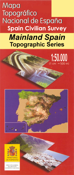
- Fuentes de Andalucia CNIG Topo 986
- Topographic coverage of mainland Spain at 1:50,000 in the MTN50 (Mapa Topográfico Nacional) series from the Centro Nacional de Información Geografica, the country’s civilian survey organization. The maps have contours at 20m intervals, enhanced by relief shading, plus colouring and/or graphics to show different types of terrain, vegetation or... Leer más

Stanfords
United Kingdom
- Andalusia Autonomous Community CNIG Physical Road Map
- Andalucía Autonomous Region of Spain at 1:400,000 on a large physical map from the IGN/CNIG - country’s civilian survey organization providing an excellent picture of the region’s topography, from the peaks of Sierra Nevada to the marshes of the Doñana National Park.Relief shading is enhanced by bright altitude colouring, with plenty of names... Leer más

Stanfords
United Kingdom
- Muntanya d’Alinyà Editorial Alpina
- Muntanya d’Alinyà, including Serra d’Aubenç and Serra de Turp, in an extensive and very popular series of walking maps from Editorial Alpina covering the Pyrenees, Catalonia and other selected hiking areas in Spain, including Picos de Europa, Sierra Nevada and parts of Andalucía, Majorca, etc. Scales vary from 1:50,000 to 1:10,000, with the... Leer más

Stanfords
United Kingdom
- Sant Llorenc del Munt i l`Obac Editorial Alpina
- Sant Llorenç del Munt i l`Obac area at 1:25,000 in an extensive and very popular series of walking maps from Editorial Alpina. Contours are at 10m intervals, enhanced by relief shading and vegetation colouring. The map has UTM grid and 1’ margin ticks. In addition to footpaths, the overprint shows various types of accommodation (hotels,... Leer más
Stanfords
United Kingdom
- Canary Islands Autonomous Region CNIG Physical Road Map
- Canary Islands Autonomous Region of Spain at 1:350,000 on a large physical map from the IGN/CNIG - country’s civilian survey organization providing an excellent picture of the region’s topography, from the peaks of the highest part of the Pyrenees, across the valley of the Ebro, to the sierras of southern Teruel province. Icons prominently... Leer más

Stanfords
United Kingdom
- Valencia - Alicante - Murcia 500K CNIG Regional Map No. 9
- The Mediterranean coast of Spain from north of Valencia to Costa Blanca and inland to include Sierras de Cazorla and Segura in north-eastern Andalucía, at 1:500,000 in a series of regional road maps from the country’s civilian survey organization IGN-CNIG (Instituto Geográfico Nacional - Centro Nacional de Información Geográfica), vividly... Leer más

Stanfords
United Kingdom
- Landscapes along the River Ter Ed. Alpina 40K Map
- Landscapes along the River Ter map in an extensive and very popular series of walking maps from Editorial Alpina covering the Pyrenees, Catalonia and other selected hiking areas in Spain, including Picos de Europa, Sierra Nevada and parts of Andalucía, Majorca, etc. Scales vary from 1:50,000 to 1:10,000, with the majority of the titles at... Leer más

Stanfords
United Kingdom
- Andalucía West: Córdoba - Seville - Málaga 500K CNIG Regional Map No. 11
- The western part of Andalucía, from Córdoba to the Straits of Gibraltar and extending along the Mediterranean coast eastwards beyond the Costa del Sol and Málaga to Nerja, at 1:500,000 in a series of regional road maps from the country’s civilian survey organization IGN-CNIG (Instituto Geográfico Nacional - Centro Nacional de Información... Leer más
Stanfords
United Kingdom
- Vall de Barravés - Ribagorça Editorial Alpina
- Val de Barravés - Ribagorça at 1:25,000 in an extensive and very popular series of walking maps from Editorial Alpina covering the Pyrenees, Catalonia and other selected hiking areas in Spain, including Picos de Europa, Sierra Nevada and parts of Andalucía, Majorca, etc.Scales of maps in this series vary from 1:50,000 to 1:10,000, with the... Leer más

Stanfords
United Kingdom
- Andalucía East: Granada - Almería - Murcia 500K CNIG Regional Map No. 12
- The eastern part of Andalucía with Granada and Sierra Nevada, extending along the Mediterranean coast from Velez-Malága to Cartagena and Mar Menor, at 1:500,000 in a series of regional road maps from the country’s civilian survey organization IGN-CNIG (Instituto Geográfico Nacional - Centro Nacional de Información Geográfica), vividly... Leer más

Stanfords
United Kingdom
- Val d`Aran by UTMB Editorial Alpina Trail running race Map
- Val d`Aran in an extensive and very popular series of walking maps from Editorial Alpina covering the Pyrenees, Catalonia and other selected hiking areas in Spain, including Picos de Europa, Sierra Nevada and parts of Andalucía, Majorca, etc. Scales vary from 1:50,000 to 1:10,000, with the majority of the titles at 1:25,000. The maps have... Leer más

Stanfords
United Kingdom