
Trentino
Descripción
Enlaces
Datos
Informes
Guías y mapas
Hospedaje
Organizaciones
Operadores turísticos
GPS
Otro
Libros

Stanfords
United Kingdom
2015
United Kingdom
2015
- Italian Lakes Walking: Garda, Maggiore, Como and Iseo
- This guidebook describes 50 walks around Lakes Como, Iseo, Garda and Maggiore in Northern Italy. The picturesque routes are accessible by public transport from popular centres including Bellagio, Riva, Stresa and Cannero, and range from 2 to 14km in length. There are gentle lakeside strolls, and numerous ridge routes and traverses as well as... Leer más

Stanfords
United Kingdom
United Kingdom
- Insight Guides Explore Italian Lakes (Travel Guide with Free eBook)
- Discover the best of the Italian Lakes with this unique travel guide, packed full of insider information and stunning images. From making sure you don`t miss out on must-see, top attractions like Lake Garda, Lake Como and Lake Maggiore, to discovering cultural gems, including the imposing Rocca Borromeo in Angera, spectacular food and wine at... Leer más

Stanfords
United Kingdom
United Kingdom
- Monti di Fundres / Pfunderer Berge Kompass 081
- Monti di Fundres / Pfunderer Berge area at 1:25,000 on a durable, waterproof and tear-resistant map from Kompass in their series of detailed maps of the Dolomites.CARTOGRAPHY: Kompass maps of the Dolomites at 1:25,000 have contours at 25-m intervals. An overprint shows local and long-distance footpaths, including all the high level routes (Alte... Leer más

Stanfords
United Kingdom
United Kingdom
- Pale di San Martino - Primiero San Martino di Castrozza - Paneveggio - Valle del Vanoi Kompass 622
- Pale di S.Martino - Fiera di Primiero - Panaveggio - Valle del Vanoi area at 1:25,000 on a durable, waterproof and tear-resistant map from Kompass in their series of detailed maps of the Dolomites.CARTOGRAPHY: Kompass maps of the Dolomites at 1:25,000 have contours at 25-m intervals. An overprint shows local and long-distance footpaths,... Leer más

Stanfords
United Kingdom
United Kingdom
- Bolzano and Environs Kompass 54
- Map No. 54, Bolzano and Environs, from Kompass, printed on waterproof and tear-resistant synthetic paper in a series of walking maps of selected areas of Italy at 1:50,000, with hiking routes on a topographic base, various types of accommodation, recreational facilities, places of interest, etc. Kompass are Europe’s largest publishers of... Leer más

Stanfords
United Kingdom
United Kingdom
- Cortina d`Ampezzo Kompass 55
- Map No. 55, Cortina d`Ampezzo - with a panorama map on the reverse, from Kompass, printed on sturdy, waterproof and tear-resistant synthetic paper in their series of walking maps of selected areas of Italy at 1:50,000, with hiking routes on a topographic base, various types of accommodation, recreational facilities, places of interest, etc.... Leer más

Stanfords
United Kingdom
United Kingdom
- Dolomiti di Braies - Pragser Dolomiten Kompass 145
- Map No. 145, Dolomiti di Braies - Pragser Dolomiten at 1:25,000 printed on sturdy waterproof and tear-resistant plastic paper. The map is part of Kompass series providing detailed coverage of the Dolomites and Lake Garda area and supplementing their main series of walking maps of Italy at 1:50,000. Maps in this series have a more detailed base... Leer más

Stanfords
United Kingdom
United Kingdom
- Parco Nazionale del Stelvio / NP Stilfser Joch Kompass 072
- Parco Nazionale del Stelvio (NP Stilfser Joch) on a GPS compatible hiking and recreational map at 1:50,000 from Kompass printed on durable, waterproof and tear-resistant synthetic paper.KOMPASS HIKING MAPS OF ITALY:This title is part of an extensive series of walking maps from Kompass covering selected areas of Italy at mainly 1:50,000, with a... Leer más

Stanfords
United Kingdom
United Kingdom
- Brunico / Bruneck - Plan de Corones / Kronplatz Kompass 045
- Brunico/Bruneck - Plan de Corones/Kronplatz area at 1:25,000 on a durable, waterproof and tear-resistant map from Kompass in their series of detailed maps of the Dolomites.CARTOGRAPHY: Kompass maps of the Dolomites at 1:25,000 have contours at 25-m intervals. An overprint shows local and long-distance footpaths, including all the high level... Leer más

Stanfords
United Kingdom
United Kingdom
- Naturno / Naturns - Laces / Latsch - Val Senales / Schnalstal Kompass 051
- Map No. 051, Naturno/Naturns - Laces/Latsch, from Kompass, printed on waterproof and tear-resistant synthetic paper in a series providing detailed coverage of the Dolomites and Lake Garda area and supplementing their main series of walking maps of Italy at 1:50,000. Maps in this series have a more detailed base and smaller contour interval than... Leer más

The Book Depository
United Kingdom
United Kingdom
- Alla Ricerca delle Trincee Nascoste
- 14 Suggestivi Itinerari alla scoperta dei Luoghi della Grande Guerra tra Veneto, Friuli Venezia Giulia e Trentino Alto Adige. Per toccare la Storia con Mano. Leer más

The Book Depository
United Kingdom
United Kingdom
- Sentieri Fantastici e Dove Trovarli
- Una Guida ai Percorsi Suggestivi e Unici tra Trentino, Veneto e Friuli-Venezia Giulia. Per rimanere Affascinati. Leer más

Stanfords
United Kingdom
2019
United Kingdom
2019
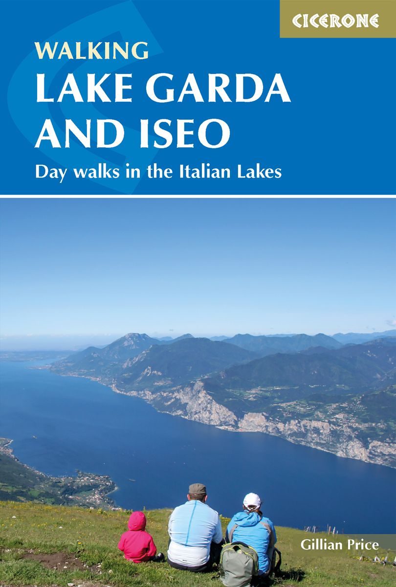
- Walking Lake Garda & Iseo
- This guidebook describes 20 walks around Lakes Garda and Iseo in Northern Italy. The routes range from 4 to 13km in length and are graded 1 to 3. There is something for everyone, from easy leisurely strolls for first-time walkers to strenuous climbs up panoramic peaks.The clear maps, inspirational photographs and information about accommodation... Leer más
- Also available from:
- The Book Depository, United Kingdom
- De Zwerver, Netherlands

The Book Depository
United Kingdom
2019
United Kingdom
2019
- Walking Lake Garda and Iseo
- Day walks in the Italian Lakes Leer más
De Zwerver
Netherlands
2019
Netherlands
2019
- Wandelgids Walking Lake Garda and Iseo | Cicerone
- Guidebook to 20 day walks around the majestic Italian lakes of Garda and Iseo. The routes, which range from leisurely strolls to more strenuous routes up panoramic peaks, offer something to suit all walkers. Invaluable practical information about public transport, accommodation and walking kit is included, together with a handy Italian glossary. Leer más

Bol.com
Netherlands
Netherlands
- Blue Guide Trentino & the South Tyrol
- Trentino and the South Tyrol (Alto Adige) in the north of Italy are high alpine regions of extraordinary beauty, perfect for trekking, skiing and enjoying the outdoors, with beautiful alpine towns and villages to explore, full of history and interest. Long a part of the Austro-Hungarian empire, the meeting of cultures in this part of Italy is... Leer más
- Also available from:
- Bol.com, Belgium
Bol.com
Belgium
Belgium
- Blue Guide Trentino & the South Tyrol
- Trentino and the South Tyrol (Alto Adige) in the north of Italy are high alpine regions of extraordinary beauty, perfect for trekking, skiing and enjoying the outdoors, with beautiful alpine towns and villages to explore, full of history and interest. Long a part of the Austro-Hungarian empire, the meeting of cultures in this part of Italy is... Leer más

Stanfords
United Kingdom
United Kingdom
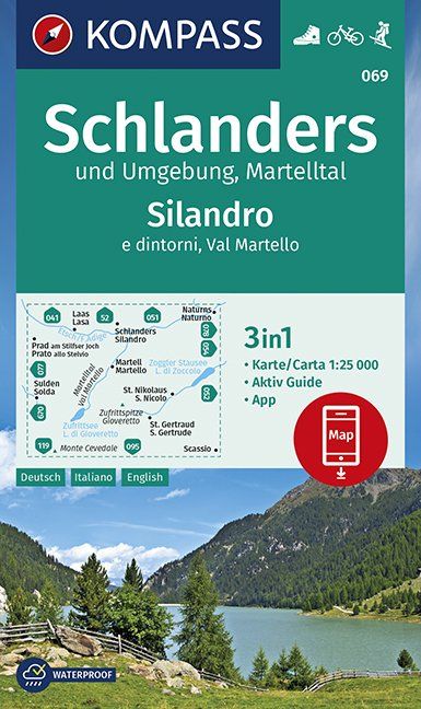
- Silandro / Schlanders and Surroundings - Val Martello / Martelltal Kompass 069
- Silandro/Schandlers and the Surrounding Area at 1:25,000 on a durable, waterproof and tear-resistant map from Kompass in their series of detailed maps of the Dolomites.CARTOGRAPHY: Kompass maps of the Dolomites at 1:25,000 have contours at 25-m intervals. An overprint shows local and long-distance footpaths, including all the high level routes... Leer más
- Also available from:
- De Zwerver, Netherlands
De Zwerver
Netherlands
Netherlands
- Wandelkaart 069 Schlanders und Umgebung - Silandro e dintorni | Kompass
- Die 3in1 Wanderkarte ist jetzt noch übersichtlicher und besser lesbar. Der Aktiv Guide informiert Sie rund um das Thema Outdoor und die kostenlose App für unterwegs gibt es auch noch dazu. Das bildet die perfekte Grundlage für die Planung einer Wandertour. Die präzise Kartografie zeigt alle begehbaren Wanderwege inklusive Klassifizierung.... Leer más
Mapas

Stanfords
United Kingdom
United Kingdom
- Cortina d`Ampezzo - Dolomiti Ampezzane Tabacco 03
- Cortina d`Ampezzo - Dolomiti Ampezzane area in a series of Tabacco maps at 1:25,000 covering the Dolomites and the mountains of north-eastern Italy - Stanfords’ most popular coverage for this region, with excellent cartography and extensive overprint for hiking routes and other recreational activities, local bus stops, etc. Additional overprint... Leer más

Stanfords
United Kingdom
United Kingdom
- Vipiteno / Sterzing Kompass 44
- Map No. 44, Vipiteno/Sterzing, from Kompass, printed on waterproof and tear-resistant synthetic paper in a series of walking maps of selected areas of Italy at 1:50,000, with hiking routes on a topographic base, various types of accommodation, recreational facilities, places of interest, etc. Kompass are Europe’s largest publishers of walking... Leer más
Stanfords
United Kingdom
United Kingdom
- Dolomiti di Braies / Pragser Dolomiten - Marebbe / Ennberg Tabacco 031
- Dolomiti di Braies/Pragser Dolomiten - Marebbe/Ennberg area in a series of Tabacco maps at 1:25,000 covering the Dolomites and the mountains of north-eastern Italy - Stanfords’ most popular coverage for this region, with excellent cartography and extensive overprint for hiking routes and other recreational activities, local bus stops, etc.... Leer más
Stanfords
United Kingdom
United Kingdom
- Cortina d`Ampezzo - Dolomiti Ampezzane Kompass 617
- Map No. 617, Cortina d’Ampezzo and Dolomiti Ampezzane at 1:25,000 on a durable, waterproof and tear-resistant map from Kompass in their series of detailed maps of the Dolomites. The map is double-sided and includes sections of the ‘Alta Via’ high routes Nos. 1, 3, 4 and 5.CARTOGRAPHY: Kompass maps of the Dolomites at 1:25,000 have contours at... Leer más

Stanfords
United Kingdom
United Kingdom
- Val d`Ultimo / Ultental Kompass 052
- Val d`Ultimo/Ultental area at 1:25,000 on a durable, waterproof and tear-resistant map from Kompass in their series of detailed maps of the Dolomites.CARTOGRAPHY: Kompass maps of the Dolomites at 1:25,000 have contours at 25-m intervals. An overprint shows local and long-distance footpaths, including all the high level routes (Alte Vie). The... Leer más
Stanfords
United Kingdom
United Kingdom
- Monti de Valle Aurina / Ahrntaler Berge Kompass 082
- Map No. 082, Monti de Valle Aurina/Ahrntaler Berge , from Kompass in a series providing detailed coverage of the Dolomites and Lake Garda area and supplementing their main series of walking maps of Italy at 1:50,000. Maps in this series have a more detailed base and smaller contour interval than coverage at 1:50,000.*Cartography:* maps at... Leer más
Stanfords
United Kingdom
2021
United Kingdom
2021
- Alpe di Siusi / Seiser Alpen Kompass 067
- Alpe di Siusi / Seiser Alpen area at 1:25,000 on a durable, waterproof and tear-resistant map from Kompass in their series of detailed maps of the Dolomites.CARTOGRAPHY: Kompass maps of the Dolomites at 1:25,000 have contours at 25-m intervals. An overprint shows local and long-distance footpaths, including all the high level routes (Alte Vie).... Leer más

Stanfords
United Kingdom
United Kingdom
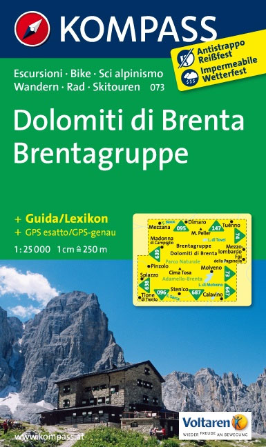
- Dolomiti di Brenta Kompass 073
- Map No. 073, Dolomiti di Brenta, from Kompass in a series providing detailed coverage of the Dolomites and Lake Garda area and supplementing their main series of walking maps of Italy at 1:50,000. Maps in this series have a more detailed base and smaller contour interval than coverage at 1:50,000.*Cartography:* maps at 1:25,000 have contours at... Leer más

Stanfords
United Kingdom
United Kingdom
- Alta Badia / Hochabtai Kompass 624
- Map No. 624, Alta Badia/Hochabtai, at 1:25,000 from Kompass, printed on sturdy, waterproof and tear-resistant synthetic paper in a series providing detailed coverage of the Dolomites and the Lake Garda area. Maps in this series supplement the publishers` main series of walking maps of Italy at 1:50,000 and have a more detailed base and smaller... Leer más
Stanfords
United Kingdom
United Kingdom
- Vipiteno / Sterzing and Environs Kompass 058
- Map No. 058, Vipiteno/Sterzing and the Surrounding Area, from Kompass in a series providing detailed coverage of the Dolomites and Lake Garda area and supplementing their main series of walking maps of Italy at 1:50,000. Maps in this series have a more detailed base and smaller contour interval than coverage at 1:50,000.*Cartography:* maps at... Leer más

Stanfords
United Kingdom
United Kingdom
- Val Gardena / Groden - Alpe di Siusi / Seiseralm Tabacco 05
- Val Gardena/Gröden - Alpe di Siusi/Seiseralm area in a series of Tabacco maps at 1:25,000 covering the Dolomites and the mountains of north-eastern Italy - Stanfords’ most popular coverage for this region, with excellent cartography and extensive overprint for hiking routes and other recreational activities, local bus stops, etc. Additional... Leer más

Stanfords
United Kingdom
United Kingdom
- Valsugana - Trento - Piné - Levico - Lavarone Kompass 75
- Valsugana - Trento - Piné - Levico – Lavarone area of southern Dolomites on a GPS compatible hiking and recreational map at 1:50,000 from Kompass, printed on durable, waterproof and tear-resistant synthetic paper. On the reverse is a panorama of the Trentino region, extending from Monte Baldo and the northern part of Lake Garda northwards to... Leer más

Stanfords
United Kingdom
United Kingdom
- Dolomiti di Sesto / Sextener Dolomiten Kompass 625
- Map No. 625, Dolomiti di Sesto/Sextener Dolomiten, at 1:25,000 from Kompass printed on sturdy, waterproof and tear-resistant synthetic paper in a series providing detailed coverage of the Dolomites and the Lake Garda area. Maps in this series supplement the publishers` main series of walking maps of Italy at 1:50,000 and have a more detailed... Leer más

Stanfords
United Kingdom
United Kingdom
- South Tyrol - Dolomites 4-Map Set Kompass 699
- Map No. 699, South Tyrol - Dolomites (4-map set) including a panorama map, from Kompass in a series of walking maps of selected areas of Italy at 1:50,000, with hiking routes on a topographic base, various types of accommodation, recreational facilities, places of interest, etc. Kompass are Europe’s largest publishers of walking maps, with... Leer más
Stanfords
United Kingdom
United Kingdom
- Val Passiria / Passeiertal Kompass 044
- Map No. 044, Val Passiria/Passeiertal, at 1:25,000 from Kompass printed on sturdy, waterproof and tear-resistant synthetic paper. The map is part of a series which provides more detailed coverage of the Dolomites and Lake Garda area and supplements the publishers` main series of walking maps of Italy at 1:50,000. Maps in this series have a more... Leer más